ExploreChilevivendo aventuras inesquecíveis


← Todas as Regiões
Magalhães e Antártica Chilena
O fim do mundo, e o começo da Antártica. A Região de Magalhães abrange o Parque Nacional Torres del Paine, cujas torres de granito e geleiras estão entre as paisagens mais fotografadas da Terra. Punta Arenas tem vista para o Estreito de Magalhães e serve como ponto de partida para cruzeiros à Antártica.
Versão em áudio disponível
Torres del Paine, Catedral da Patagônia
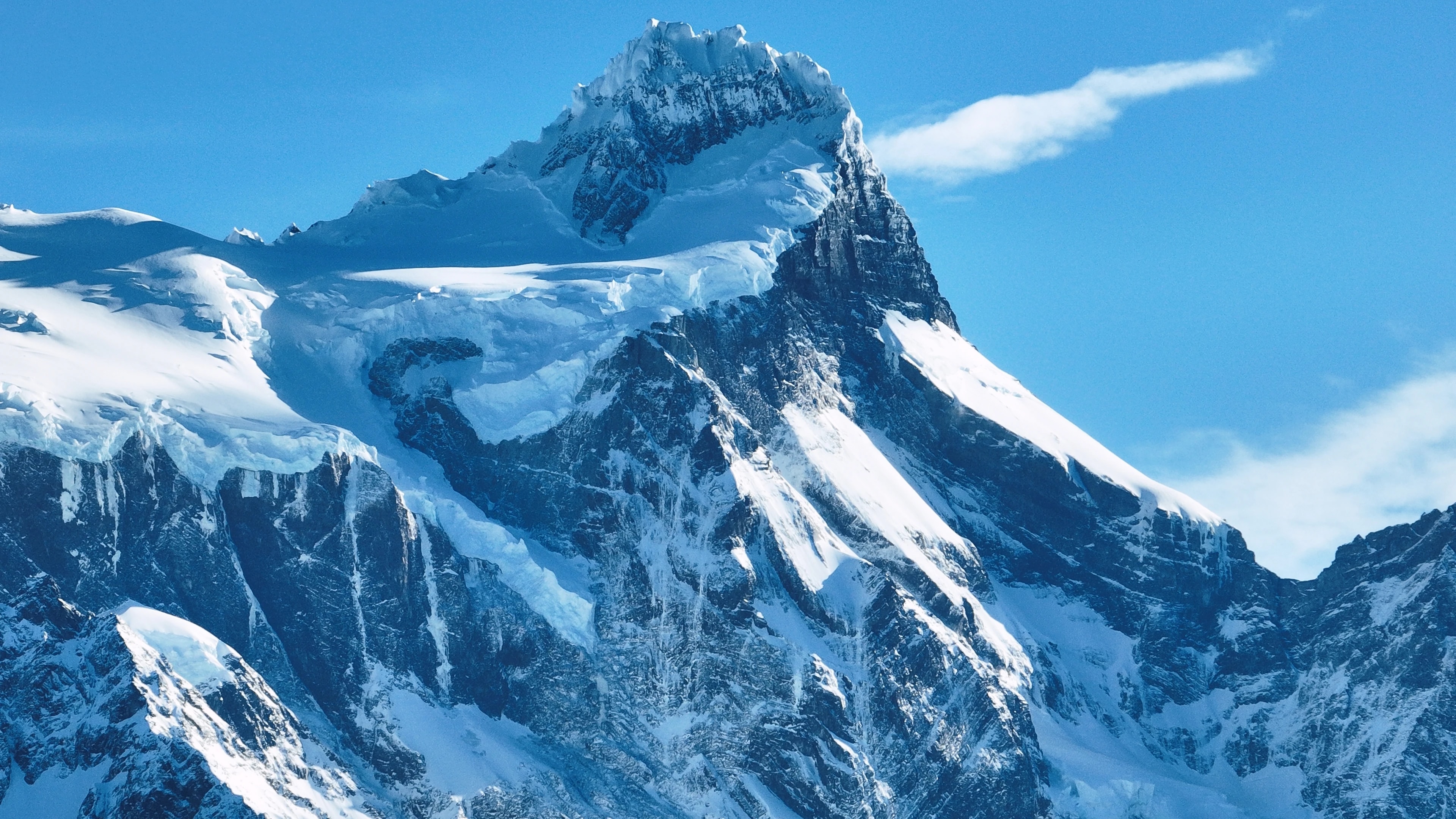
O Parque Nacional Torres del Paine é, para muitos viajantes, o motivo de vir ao Chile. As três torres de granito, pilares de rocha que brilham em rosa ao nascer do sol, são a imagem icônica do parque, mas são apenas o começo. O parque abrange um maciço montanhoso inteiro cercado por lagos de azul elétrico, geleiras suspensas, campos de guanacos e florestas de lenga que se tornam douradas no outono.
O Circuito W, uma caminhada de 4–5 dias que visita as torres, o Vale Francês e a Geleira Grey, é uma das trilhas de vários dias mais famosas do mundo, enquanto o Circuito O completo (7–9 dias) contorna todo o maciço por terras selvagens que poucos visitantes veem.
A Geleira Grey, um braço do Campo de Gelo Patagônico Sul, liberta icebergs no Lago Grey que passam flutuando por caiaqueiros e passageiros de catamarã em um jardim de esculturas azuis em constante mudança. O parque é lar de pumas, condores andinos, raposas e uma das populações de guanacos mais saudáveis do continente.
Punta Arenas, Porta de Entrada para a Antártica
Punta Arenas, a capital regional, é a cidade mais austral de seu porte no mundo, um porto batido pelo vento com 130.000 habitantes debruçado sobre o Estreito de Magalhães que separa o continente sul-americano da Terra do Fogo. Fundada como colônia penal e estação de reabastecimento em 1848, cresceu rica durante o boom da criação de ovelhas no final do século XIX, e as grandes mansões ao redor da Plaza de Armas, em especial o Palacio Sara Braun, atestam as fortunas feitas pelos barões da lã patagônica.
Hoje, Punta Arenas é ponto de partida para cruzeiros de expedição à Antártica, com navios rumando ao sul pela Passagem de Drake rumo ao continente branco.
O Cemitério Municipal da cidade, com suas alamedas de ciprestes e mausoléus elaborados, é considerado um dos mais bonitos das Américas. Nas proximidades, a colônia de pinguins da Ilha Magdalena, 60.000 casais reprodutores de pinguins-de-magalhães, é acessível por uma curta viagem de balsa.
Terra do Fogo, O Fim da Terra
Do outro lado do Estreito de Magalhães, a metade chilena da Terra do Fogo é uma vastidão varrida pelo vento de pastagens, turfeiras e as florestas mais austrais do planeta. Porvenir, o principal assentamento da ilha, é uma tranquila cidade de casas com telhado de lata e uma história de corrida do ouro, onde culturas imigrantes chilenas e croatas se misturam em uma atmosfera de fronteira.
O interior da ilha abriga vastas estâncias onde ovelhas superam pessoas por ordens de grandeza, e a colônia de pinguins-rei em Bahía Inútil, a única colônia significativa de pinguins-rei na América do Sul continental, é uma das experiências mais extraordinárias de vida selvagem da região.
No extremo sul da ilha, o Parque Karukinka, estabelecido pela Wildlife Conservation Society, protege as últimas florestas intactas da Terra do Fogo, ancestrais lengas e coigües que abrigam a ameaçada raposa culpeo, pica-paus patagônicos e o esquivo cervo huemul.
Geleiras, Fiordes e os Campos de Gelo
A Região de Magalhães contém o Campo de Gelo Patagônico Sul, com 13.000 km², a terceira maior reserva de água doce do mundo, atrás apenas da Antártica e da Groenlândia. Suas geleiras descem pelos Andes em fiordes e lagos que estão entre as paisagens aquáticas mais espetaculares da Terra. As geleiras Grey, Tyndall e Balmaceda são acessíveis a partir de Torres del Paine e Puerto Natales, enquanto a mais remota Geleira Pío XI, a maior do Hemisfério Sul fora da Antártica, só pode ser alcançada por expedições de barco de vários dias pelos fiordes.
Os canais de 'Última Esperança' são lar de baleias-jubarte, focas-leopardo e golfinhos-de-commerson, e o passeio de barco de Puerto Natales às geleiras Balmaceda e Serrano atravessa cenários de grandiosidade estonteante.
O Parque Nacional Bernardo O'Higgins, a maior área protegida do Chile, abrange grande parte desse campo de gelo e suas terras selvagens ao redor, uma região tão vasta e inacessível que grandes porções permanecem inexploradas.
Cultura Patagônica, Vento, Lã e Asado
A vida em Magalhães é moldada pelos elementos: o implacável vento patagônico que entorta árvores horizontalmente, a longa escuridão do inverno e os breves porém luminosos verões quando o sol quase não se põe. Esse ambiente severo forjou uma cultura distinta de autossuficiência, cordialidade e humor ácido. As estâncias, muitas ainda em operação como fazendas de ovelhas, oferecem uma janela autêntica para esse mundo: visitantes podem participar da tosquia de ovelhas, das cavalgadas de arrodeio e do preparo do lendário asado al palo patagônico, onde um cordeiro inteiro é aberto em uma cruz de metal e assado lentamente sobre fogo aberto por horas.
Em Puerto Natales, a charmosa cidade-portal para Torres del Paine, restaurantes servem centolla (caranguejo-rei) tirada dos fiordes naquela manhã, acompanhada de sobremesas de calafate, um arbusto nativo cuja baga, segundo a lenda local, garante que todo aquele que a comer retornará à Patagônia.
Poucos que visitam discordariam.
Pontos de Interesse
Cidades
Cidades
Puerto Natales
Western gateway to Parque Nacional Torres del Paine and the launching point for Patagonian fjord cruises, Puerto Natales sits on Última Esperanza Sound 250 km north of Punta Arenas. The town began as a sheep-ranching outpost in the 1880s; its old Frigorífico Bories cold-store complex, now a museum, is the largest surviving industrial monument in Chilean Patagonia. Today its waterfront, lined with hostels and outfitters, is the staging area for the 'W' and 'O' treks through Torres del Paine.
Cidades
Punta Arenas
Capital of Magallanes and largest city in Chilean Patagonia, founded in 1848 as a penal colony on the Strait of Magellan. Punta Arenas grew rich on the late-nineteenth-century wool boom, leaving behind the European-style mansions of the Sara Braun and Menéndez families around Plaza Muñoz Gamero. Today it is the embarkation point for Antarctic expeditions and the cruise route to Cape Horn, and its Cementerio Municipal is considered one of the most striking historic cemeteries in South America.
Cidades
Porvenir
Capital of the Chilean side of Tierra del Fuego, founded during the 1880s gold rush as miners poured into the island. Porvenir sits across the Strait of Magellan from Punta Arenas, reached by a two-hour ferry from Bahía Chilota or a longer crossing from Punta Delgada. The town's small Croatian community, descendants of immigrant miners, is commemorated in the Museo Fernando Cordero Rusque, and Bahía Inútil to the south hosts one of the largest king penguin colonies outside Antarctica.
Cidades
Puerto Williams
Southernmost permanently inhabited settlement in the world, on Isla Navarino south of the Beagle Channel. Founded in 1953 as a Chilean naval base to assert sovereignty against Argentina's Ushuaia across the channel, Puerto Williams remains the seat of Cabo de Hornos Province. The town is the access point for the Dientes de Navarino trek and the last waypoint for yachts bound for Cape Horn or the Antarctic Peninsula.
Reservas Naturais
Reservas Naturais
Parque Nacional Bernardo O'Higgins
Chile's largest national park at 3.5 million hectares, covering most of the Southern Patagonian Ice Field and the maze of fjords running north into Aysén. The park contains 49 glaciers — including Pío XI, the largest non-polar glacier in the southern hemisphere — and is accessed only by boat from Puerto Natales or Puerto Edén.
Reservas Naturais
Parque Nacional Kawésqar
Created in 2019 by upgrading the former Alacalufes National Reserve, Kawésqar covers 2.8 million hectares of fjords, channels and ice fields west of Puerto Natales. The park is named for the Kawésqar, canoe-faring nomads who navigated these waters for at least 6,000 years and whose last fluent speakers still live in Puerto Edén.
Reservas Naturais
Cueva del Milodón
A 200-metre limestone cave 24 km north of Puerto Natales where, in 1895, a German settler discovered a piece of mylodon hide — the partly mummified skin of a giant ground sloth that lived here at the end of the Ice Age. The find triggered international fossil expeditions and is referenced in Bruce Chatwin's 'In Patagonia'. A life-size mylodon statue stands at the cave entrance.
Reservas Naturais
Glaciar Serrano
Tidewater glacier in the Southern Patagonian Ice Field, reached by a half-day boat journey up Última Esperanza Sound and the Río Serrano from Puerto Natales. The trip threads past calving icebergs and the towering Cerro Balmaceda before arriving at a small landing on the glacier's face.
Reservas Naturais
Glaciar Grey
Twelve-kilometre-wide glacier flowing east off the Southern Patagonian Ice Field into Lago Grey, on the western edge of Torres del Paine. Icebergs calved from its face drift across the lake to a black-sand beach at its eastern end. Catamaran tours from Hostería Lago Grey navigate among the floes, and the glacier marks the second day of the 'W' trek.
Reservas Naturais
Parque Nacional Torres del Paine
Chile's most celebrated national park (242,000 hectares), centred on the three granite spires of the Paine Massif rising 2,800 m above the Patagonian steppe. The 'W' and 'O' treks circling the massif have become the most famous multi-day hikes in South America. Inside the park: Grey Glacier flowing off the Southern Patagonian Ice Field, the milky-blue Lago Pehoé, and herds of guanacos that recovered after pumas drove them back from the brink.
Reservas Naturais
Parque Nacional Pali Aike
Volcanic steppe park 200 km north-east of Punta Arenas, on the Chilean–Argentine border. Pali Aike means 'devil's country' in the Tehuelche language: the moonscape of cinder cones, lava flows and pampa is dotted with caves where some of the oldest human remains in the Americas (10,000+ BP) have been excavated.
Reservas Naturais
Reserva Nacional Magallanes
A 20,000-hectare reserve right at the back door of Punta Arenas, protecting Lenga forest and the watersheds of the Río de las Minas. Trails climb to the Cerro Mirador viewpoint and the small Andino Club ski centre — the southernmost in continental South America.
Reservas Naturais
Isla Magdalena
A treeless 85-hectare island in the Strait of Magellan, two hours by boat from Punta Arenas, hosting a colony of about 120,000 Magellanic penguins between October and March. A clearly-marked boardwalk threads through the burrows; the rest of the island is closed to protect the nesting birds.
Reservas Naturais
Parque Pingüino Rey
Private 4,000-hectare reserve on Bahía Inútil in north-central Chilean Tierra del Fuego, protecting the only king-penguin colony on the South American continent — about 60 birds that returned to the bay in 2010 after a century of being hunted nearly to extinction. A short boardwalk skirts the colony at a respectful distance; visits are by guided tour, and the king penguins are present year-round with chicks visible from late summer.
Reservas Naturais
Parque Karukinka
297,000-hectare conservation park covering the southern half of Chilean Tierra del Fuego, managed by the Wildlife Conservation Society after Goldman Sachs donated the land in 2004. Karukinka, which means 'our land' in the Selk'nam language, protects sub-Antarctic forests, peatlands and the largest guanaco population in southern Chile.
Reservas Naturais
Isla Santa Inés
Large remote island west of Tierra del Fuego, draped in southern Patagonian rainforest and capped by the De Agostini ice field. Inhabited only by occasional crab fishermen, the island is accessible mainly by expedition cruise and remains one of the least-visited corners of Chilean Patagonia.
Reservas Naturais
Parque Nacional Alberto de Agostini
Vast 1.46-million-hectare park covering the Cordillera Darwin range and a maze of southern Tierra del Fuego fjords, named for the Italian Salesian priest who first explored and mapped the area in the early twentieth century. Accessible only by sea, the park's tidewater glaciers — including the Pía and Garibaldi — are highlights of cruise itineraries from Punta Arenas to Ushuaia.
Reservas Naturais
Parque Nacional Cabo de Hornos
Southernmost national park in the world, covering Isla Hornos and the surrounding archipelago at the convergence of the Pacific and Atlantic oceans. Cape Horn, the rocky headland that marks the navigational southern tip of the Americas, has been a UNESCO Biosphere Reserve since 2005 for its sub-Antarctic mossy forests, peat bogs, and the only known species-rich miniature flora in the world.