ExploreChileпроживая незабываемые приключения


← Все регионы
Магальянес и Чилийская Антарктика
Край света, и начало Антарктиды. Регион Магальянес включает национальный парк Торрес-дель-Пайне, чьи гранитные башни и ледники входят в число самых фотографируемых ландшафтов на Земле. Столица Пунта-Аренас смотрит на Магелланов пролив и служит отправной точкой антарктических круизов.
Доступна аудиоверсия
Торрес-дель-Пайне, собор Патагонии
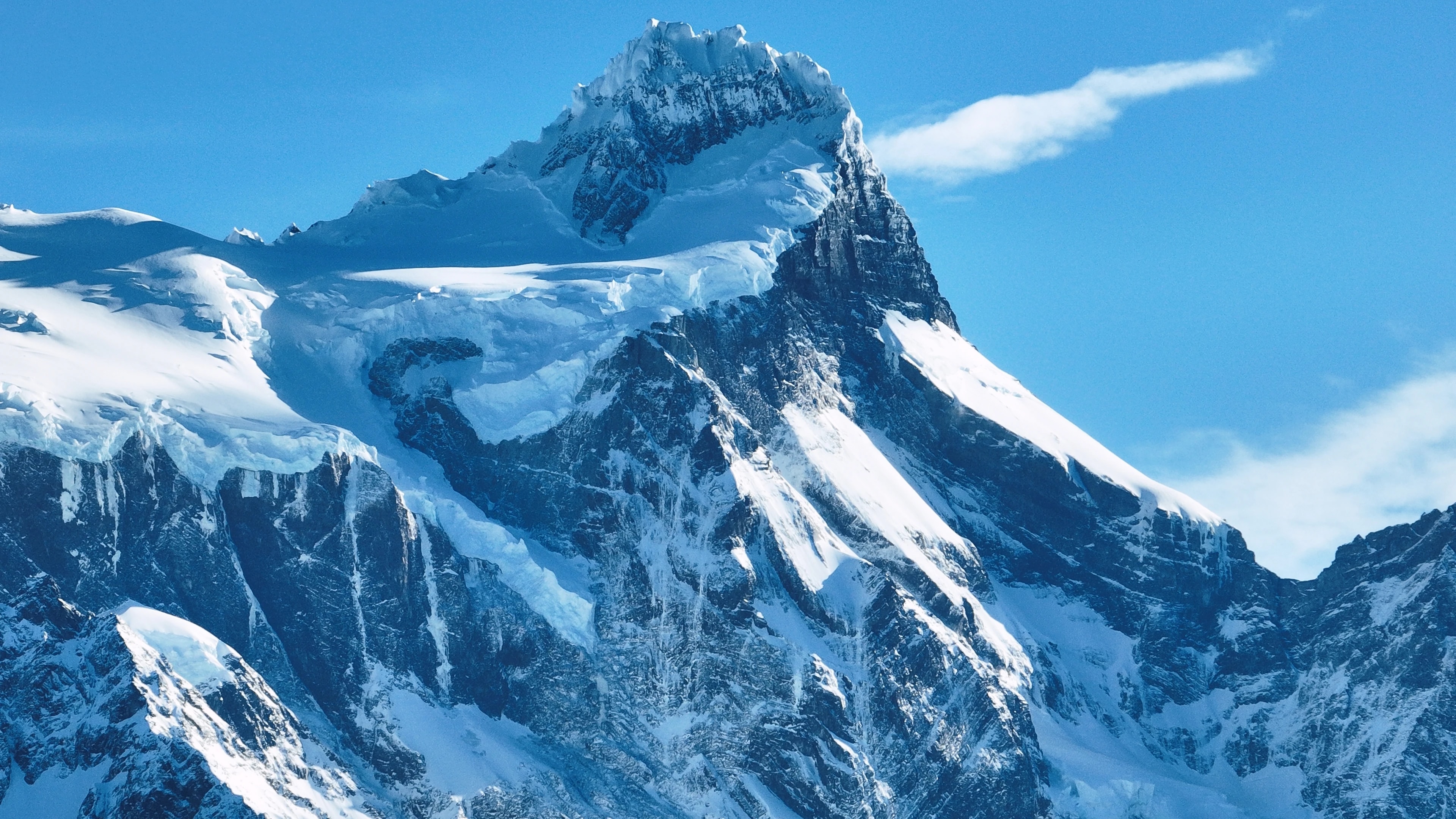
Национальный парк Торрес-дель-Пайне для многих путешественников, главная причина ехать в Чили. Три гранитные башни, взмывающие столбы скалы, порозовевшие на рассвете,, культовый образ парка, но лишь его начало. Парк охватывает целый горный массив, окружённый электрически-синими озёрами, висячими ледниками, степями с гуанако и лесами южного бука ленга, золотеющими осенью.
Трек W, 4–5-дневный маршрут к башням, Французской долине и леднику Грэй, один из самых знаменитых многодневных маршрутов мира, а полный круг O (7–9 дней) огибает весь массив через дикую местность, которую немногие видят.
Ледник Грэй, рукав Южного Патагонского ледяного поля, отёлывает айсберги в озеро Грэй, проплывающие мимо каякеров и пассажиров катамарана как постоянно меняющийся голубой скульптурный сад. Парк, дом пум, андских кондоров, лисиц и одной из самых здоровых популяций гуанако на континенте.
Пунта-Аренас, ворота в Антарктику
Пунта-Аренас, столица региона,, самый южный город своего размера в мире: обдуваемый ветрами порт с 130 000 жителей, глядящий на Магелланов пролив, отделяющий материк от Огненной Земли. Основанный как каторжная колония и угольная станция в 1848 году, он разбогател в эпоху овцеводческого бума конца XIX века, и роскошные особняки вдоль Пласа-де-Армас, особенно Паласио Сара-Браун, свидетельствуют о состояниях, нажитых на патагонской шерсти.
Сегодня Пунта-Аренас, отправная точка антарктических экспедиционных круизов, чьи суда следуют на юг через пролив Дрейка к белому континенту.
Муниципальное кладбище города, с его кипарисовыми аллеями и вычурными мавзолеями, считается одним из красивейших кладбищ обеих Америк. Неподалёку колония пингвинов острова Магдалена, 60 000 гнездящихся пар магеллановых пингвинов, всего в короткой поездке на пароме.
Огненная Земля, край света
По ту сторону Магелланова пролива чилийская половина Огненной Земли, продуваемый ветрами простор лугов, торфяников и самых южных лесов планеты. Порвенир, главное поселение острова,, тихий городок жестяных крыш и золотоискательской истории, где чилийская и хорватская иммигрантские культуры смешиваются в атмосфере фронтира.
Внутренние территории острова скрывают обширные эстансии, где овцы превосходят людей числом на порядки, а колония королевских пингвинов в Баия-Инутиль, единственная значительная колония этого вида на материковой Южной Америке, одно из самых необыкновенных зрелищ региона.
На южной оконечности острова Парке-Карукинка, основанный Обществом охраны дикой природы, оберегает последние нетронутые леса Огненной Земли, древние ленга и койгуэ, укрывающие исчезающую лисицу кульпео, патагонских дятлов и неуловимого оленя уэмуль.
Ледники, фьорды и ледяные поля
Регион Магальянес содержит Южное Патагонское ледяное поле, при 13 000 квадратных километрах третий по величине запас пресной воды в мире после Антарктиды и Гренландии. Его ледники стекают через Анды во фьорды и озёра, создавая одни из самых впечатляющих водных пейзажей на Земле. Ледники Грэй, Тиндалл и Бальмаседа доступны из Торрес-дель-Пайне и Пуэрто-Наталес, а более удалённый ледник Пио XI, крупнейший в Южном полушарии за пределами Антарктиды, достижим лишь многодневными экспедициями на лодке через фьорды.
Каналы Ультима-Эсперанса («Последней Надежды»), дом горбатых китов, морских леопардов и дельфинов Коммерсона, а лодочная экскурсия из Пуэрто-Наталес к ледникам Бальмаседа и Серрано проходит через пейзажи ошеломительного величия.
Национальный парк Бернардо О'Хиггинс, крупнейшая охраняемая территория Чили, охватывает значительную часть ледяного поля и окружающей дикой местности, территорию настолько обширную и недоступную, что значительные её участки остаются неисследованными.
Патагонская культура, ветер, шерсть и асадо
Жизнь в Магальянесе определяется стихиями: неослабевающий патагонский ветер, гнущий деревья горизонтально, долгая зимняя темнота и краткое, но лучезарное лето, когда солнце почти не заходит. Эта суровая среда выковала самобытную культуру самодостаточности, душевного тепла и тёмного юмора. Эстансии, многие по-прежнему действующие овечьи ранчо, предлагают подлинное окно в этот мир: гости могут участвовать в стрижке овец, конных перегонах и приготовлении легендарного патагонского асадо-аль-пало, когда целый ягнёнок распластан на металлическом кресте и медленно жарится на открытом огне часами.
В Пуэрто-Наталес, уютном городке-воротах к Торрес-дель-Пайне, рестораны подают сентолью (королевского краба), выловленного этим утром из фьордов, вместе с десертами из ягоды калафате, кустарника, чьи плоды, согласно местной легенде, гарантируют, что каждый, кто их попробует, вернётся в Патагонию.
Мало кто из побывавших стал бы спорить.
Достопримечательности
Города
Города
Puerto Natales
Western gateway to Parque Nacional Torres del Paine and the launching point for Patagonian fjord cruises, Puerto Natales sits on Última Esperanza Sound 250 km north of Punta Arenas. The town began as a sheep-ranching outpost in the 1880s; its old Frigorífico Bories cold-store complex, now a museum, is the largest surviving industrial monument in Chilean Patagonia. Today its waterfront, lined with hostels and outfitters, is the staging area for the 'W' and 'O' treks through Torres del Paine.
Города
Punta Arenas
Capital of Magallanes and largest city in Chilean Patagonia, founded in 1848 as a penal colony on the Strait of Magellan. Punta Arenas grew rich on the late-nineteenth-century wool boom, leaving behind the European-style mansions of the Sara Braun and Menéndez families around Plaza Muñoz Gamero. Today it is the embarkation point for Antarctic expeditions and the cruise route to Cape Horn, and its Cementerio Municipal is considered one of the most striking historic cemeteries in South America.
Города
Porvenir
Capital of the Chilean side of Tierra del Fuego, founded during the 1880s gold rush as miners poured into the island. Porvenir sits across the Strait of Magellan from Punta Arenas, reached by a two-hour ferry from Bahía Chilota or a longer crossing from Punta Delgada. The town's small Croatian community, descendants of immigrant miners, is commemorated in the Museo Fernando Cordero Rusque, and Bahía Inútil to the south hosts one of the largest king penguin colonies outside Antarctica.
Города
Puerto Williams
Southernmost permanently inhabited settlement in the world, on Isla Navarino south of the Beagle Channel. Founded in 1953 as a Chilean naval base to assert sovereignty against Argentina's Ushuaia across the channel, Puerto Williams remains the seat of Cabo de Hornos Province. The town is the access point for the Dientes de Navarino trek and the last waypoint for yachts bound for Cape Horn or the Antarctic Peninsula.
Природные заповедники
Природные заповедники
Parque Nacional Bernardo O'Higgins
Chile's largest national park at 3.5 million hectares, covering most of the Southern Patagonian Ice Field and the maze of fjords running north into Aysén. The park contains 49 glaciers — including Pío XI, the largest non-polar glacier in the southern hemisphere — and is accessed only by boat from Puerto Natales or Puerto Edén.
Природные заповедники
Parque Nacional Kawésqar
Created in 2019 by upgrading the former Alacalufes National Reserve, Kawésqar covers 2.8 million hectares of fjords, channels and ice fields west of Puerto Natales. The park is named for the Kawésqar, canoe-faring nomads who navigated these waters for at least 6,000 years and whose last fluent speakers still live in Puerto Edén.
Природные заповедники
Cueva del Milodón
A 200-metre limestone cave 24 km north of Puerto Natales where, in 1895, a German settler discovered a piece of mylodon hide — the partly mummified skin of a giant ground sloth that lived here at the end of the Ice Age. The find triggered international fossil expeditions and is referenced in Bruce Chatwin's 'In Patagonia'. A life-size mylodon statue stands at the cave entrance.
Природные заповедники
Glaciar Serrano
Tidewater glacier in the Southern Patagonian Ice Field, reached by a half-day boat journey up Última Esperanza Sound and the Río Serrano from Puerto Natales. The trip threads past calving icebergs and the towering Cerro Balmaceda before arriving at a small landing on the glacier's face.
Природные заповедники
Glaciar Grey
Twelve-kilometre-wide glacier flowing east off the Southern Patagonian Ice Field into Lago Grey, on the western edge of Torres del Paine. Icebergs calved from its face drift across the lake to a black-sand beach at its eastern end. Catamaran tours from Hostería Lago Grey navigate among the floes, and the glacier marks the second day of the 'W' trek.
Природные заповедники
Parque Nacional Torres del Paine
Chile's most celebrated national park (242,000 hectares), centred on the three granite spires of the Paine Massif rising 2,800 m above the Patagonian steppe. The 'W' and 'O' treks circling the massif have become the most famous multi-day hikes in South America. Inside the park: Grey Glacier flowing off the Southern Patagonian Ice Field, the milky-blue Lago Pehoé, and herds of guanacos that recovered after pumas drove them back from the brink.
Природные заповедники
Parque Nacional Pali Aike
Volcanic steppe park 200 km north-east of Punta Arenas, on the Chilean–Argentine border. Pali Aike means 'devil's country' in the Tehuelche language: the moonscape of cinder cones, lava flows and pampa is dotted with caves where some of the oldest human remains in the Americas (10,000+ BP) have been excavated.
Природные заповедники
Reserva Nacional Magallanes
A 20,000-hectare reserve right at the back door of Punta Arenas, protecting Lenga forest and the watersheds of the Río de las Minas. Trails climb to the Cerro Mirador viewpoint and the small Andino Club ski centre — the southernmost in continental South America.
Природные заповедники
Isla Magdalena
A treeless 85-hectare island in the Strait of Magellan, two hours by boat from Punta Arenas, hosting a colony of about 120,000 Magellanic penguins between October and March. A clearly-marked boardwalk threads through the burrows; the rest of the island is closed to protect the nesting birds.
Природные заповедники
Parque Pingüino Rey
Private 4,000-hectare reserve on Bahía Inútil in north-central Chilean Tierra del Fuego, protecting the only king-penguin colony on the South American continent — about 60 birds that returned to the bay in 2010 after a century of being hunted nearly to extinction. A short boardwalk skirts the colony at a respectful distance; visits are by guided tour, and the king penguins are present year-round with chicks visible from late summer.
Природные заповедники
Parque Karukinka
297,000-hectare conservation park covering the southern half of Chilean Tierra del Fuego, managed by the Wildlife Conservation Society after Goldman Sachs donated the land in 2004. Karukinka, which means 'our land' in the Selk'nam language, protects sub-Antarctic forests, peatlands and the largest guanaco population in southern Chile.
Природные заповедники
Isla Santa Inés
Large remote island west of Tierra del Fuego, draped in southern Patagonian rainforest and capped by the De Agostini ice field. Inhabited only by occasional crab fishermen, the island is accessible mainly by expedition cruise and remains one of the least-visited corners of Chilean Patagonia.
Природные заповедники
Parque Nacional Alberto de Agostini
Vast 1.46-million-hectare park covering the Cordillera Darwin range and a maze of southern Tierra del Fuego fjords, named for the Italian Salesian priest who first explored and mapped the area in the early twentieth century. Accessible only by sea, the park's tidewater glaciers — including the Pía and Garibaldi — are highlights of cruise itineraries from Punta Arenas to Ushuaia.
Природные заповедники
Parque Nacional Cabo de Hornos
Southernmost national park in the world, covering Isla Hornos and the surrounding archipelago at the convergence of the Pacific and Atlantic oceans. Cape Horn, the rocky headland that marks the navigational southern tip of the Americas, has been a UNESCO Biosphere Reserve since 2005 for its sub-Antarctic mossy forests, peat bogs, and the only known species-rich miniature flora in the world.