ExploreChileviviendo aventuras inolvidables


← Todas las Regiones
Magallanes y de la Antártica Chilena
El fin del mundo, y el comienzo de la Antártica. La Región de Magallanes abarca el Parque Nacional Torres del Paine, cuyas torres de granito y glaciares figuran entre los paisajes más fotografiados del planeta. Punta Arenas se asoma al Estrecho de Magallanes y sirve como punto de partida para cruceros antárticos.
Versión de audio disponible
Torres del Paine, Catedral de la Patagonia
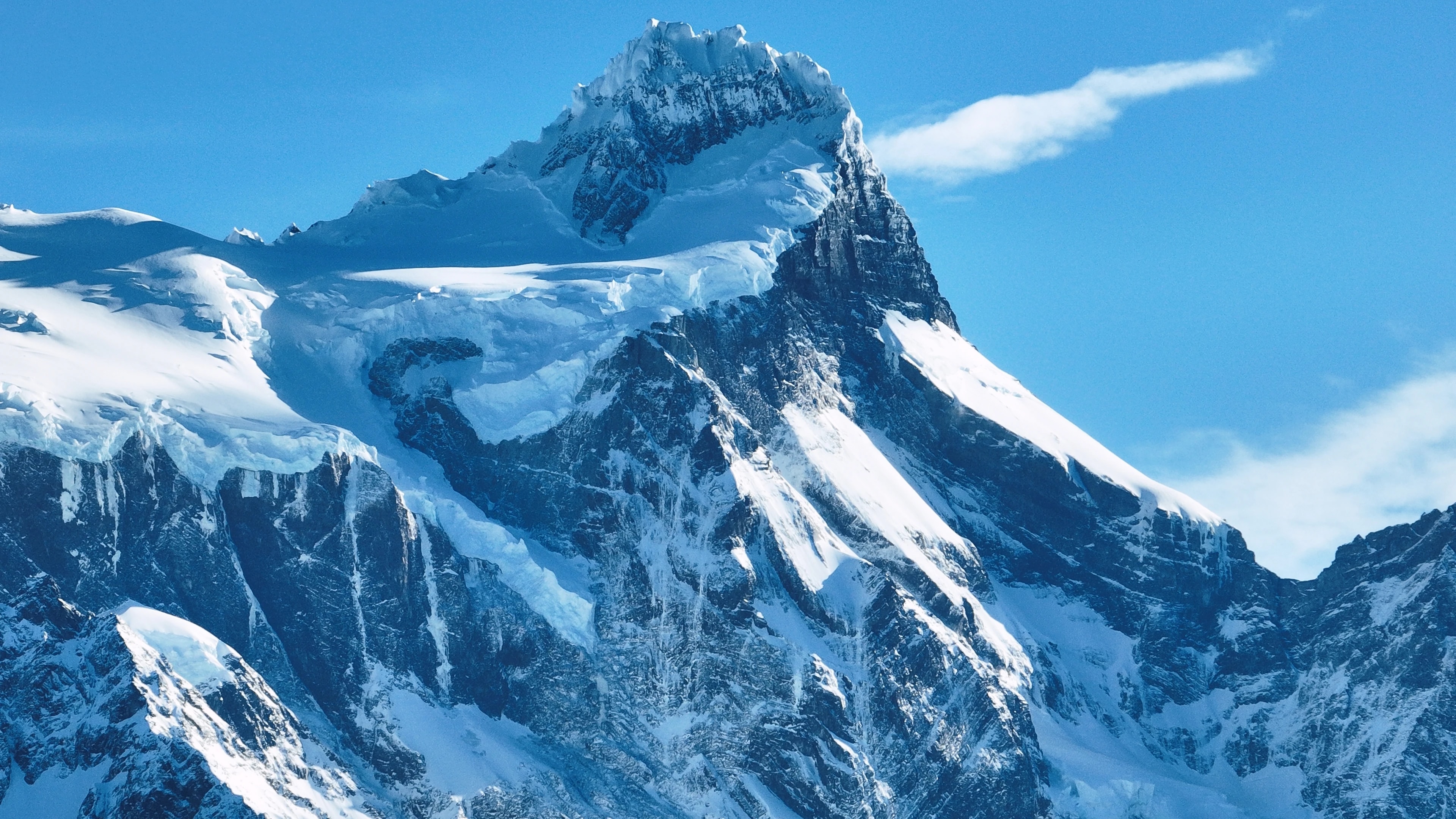
El Parque Nacional Torres del Paine es, para muchos viajeros, la razón para venir a Chile. Las tres torres de granito, pilares de roca que se tiñen de rosa al amanecer, son la imagen icónica del parque, pero son apenas el comienzo. El parque abarca un macizo montañoso entero rodeado de lagos azul eléctrico, glaciares colgantes, praderas recorridas por guanacos y bosques de lenga que se tornan dorados en otoño.
El Trekking W, un circuito de 4 a 5 días que visita las torres, el Valle del Francés y el Glaciar Grey, es una de las caminatas de varios días más famosas del mundo, mientras el circuito O completo (7-9 días) rodea todo el macizo por una naturaleza salvaje que pocos visitantes conocen.
El Glaciar Grey, un brazo del Campo de Hielo Sur, desprende témpanos en el Lago Grey que derivan ante kayakistas y pasajeros de catamarán en un jardín de esculturas azules en constante cambio. El parque alberga pumas, cóndores andinos, zorros y una de las poblaciones de guanacos más saludables del continente.
Punta Arenas, Puerta de Entrada a la Antártica
Punta Arenas, la capital regional, es la ciudad más austral de su tamaño en el mundo, un puerto azotado por el viento de 130.000 habitantes que se asoma al Estrecho de Magallanes, que separa el continente sudamericano de Tierra del Fuego. Fundada como colonia penal y estación de carboneo en 1848, creció con la bonanza ovina de fines del siglo XIX, y las grandes mansiones a lo largo de la Plaza de Armas, en particular el Palacio Sara Braun, atestiguan las fortunas amasadas con la lana patagónica.
Hoy, Punta Arenas es el punto de partida de cruceros de expedición a la Antártica, con navíos rumbo al sur a través del Paso Drake hacia el continente blanco.
El Cementerio Municipal de la ciudad, con sus avenidas de cipreses y elaborados mausoleos, está considerado uno de los cementerios más bellos de las Américas. Cerca de allí, la colonia de pingüinos de Isla Magdalena, 60.000 parejas reproductivas de pingüino de Magallanes, queda a un breve viaje en ferry.
Tierra del Fuego, El Fin de la Tierra
Al otro lado del Estrecho de Magallanes, la mitad chilena de Tierra del Fuego es una extensión azotada por el viento de pastizales, turberas y los bosques más australes del planeta. Porvenir, el principal asentamiento de la isla, es un pueblo tranquilo de casas con tejados de zinc y una historia de fiebre del oro, donde las culturas de inmigrantes chilenos y croatas se mezclan en una atmósfera de frontera.
El interior de la isla alberga vastas estancias donde las ovejas superan a los humanos en proporciones abrumadoras, y la colonia de pingüinos rey en Bahía Inútil, la única colonia significativa de pingüinos rey en la Sudamérica continental, es una de las experiencias de fauna más extraordinarias de la región.
En el extremo sur de la isla, el Parque Karukinka, establecido por la Wildlife Conservation Society, protege los últimos bosques intactos de Tierra del Fuego, lengas y coigües ancestrales que dan refugio al amenazado zorro culpeo, carpinteros patagónicos y el esquivo huemul.
Glaciares, Fiordos y los Campos de Hielo
La Región de Magallanes contiene el Campo de Hielo Sur, con 13.000 kilómetros cuadrados, la tercera mayor reserva de agua dulce del mundo después de la Antártica y Groenlandia. Sus glaciares descienden por los Andes hacia fiordos y lagos que se cuentan entre los paisajes acuáticos más espectaculares de la Tierra. Los glaciares Grey, Tyndall y Balmaceda son accesibles desde Torres del Paine y Puerto Natales, mientras el más remoto Glaciar Pío XI, el mayor del hemisferio sur fuera de la Antártica, solo se alcanza mediante expediciones en barco de varios días a través de los fiordos.
Los canales de Última Esperanza albergan ballenas jorobadas, focas leopardo y delfines de Commerson, y el viaje en barco desde Puerto Natales a los glaciares Balmaceda y Serrano transcurre por paisajes de grandiosidad sobrecogedora.
El Parque Nacional Bernardo O'Higgins, el área protegida más grande de Chile, abarca gran parte de este campo de hielo y su naturaleza circundante, una región tan vasta e inaccesible que grandes porciones permanecen inexploradas.
Cultura Patagónica, Viento, Lana y Asado
La vida en Magallanes está moldeada por los elementos: el viento patagónico implacable que tuerce los árboles en horizontal, la larga oscuridad invernal y los breves pero luminosos veranos cuando el sol apenas se pone. Este entorno agreste ha forjado una cultura distintiva de autosuficiencia, calidez y humor negro. Las estancias, muchas aún en funcionamiento como ranchos ovejeros, ofrecen una ventana auténtica a este mundo: los visitantes pueden participar en la esquila, arreos a caballo y la preparación del legendario asado al palo patagónico, donde un cordero entero se abre sobre una cruz de metal y se asa lentamente al fuego abierto durante horas.
En Puerto Natales, el encantador pueblo puerta a Torres del Paine, los restaurantes sirven centolla extraída de los fiordos esa mañana, acompañada de postres de calafate, una baya nativa cuyo arbusto, según la leyenda local, garantiza que quien la prueba volverá a la Patagonia.
Pocos que la visitan estarían en desacuerdo.
Puntos de Interés
Ciudades
Ciudades
Puerto Natales
Western gateway to Parque Nacional Torres del Paine and the launching point for Patagonian fjord cruises, Puerto Natales sits on Última Esperanza Sound 250 km north of Punta Arenas. The town began as a sheep-ranching outpost in the 1880s; its old Frigorífico Bories cold-store complex, now a museum, is the largest surviving industrial monument in Chilean Patagonia. Today its waterfront, lined with hostels and outfitters, is the staging area for the 'W' and 'O' treks through Torres del Paine.
Ciudades
Punta Arenas
Capital of Magallanes and largest city in Chilean Patagonia, founded in 1848 as a penal colony on the Strait of Magellan. Punta Arenas grew rich on the late-nineteenth-century wool boom, leaving behind the European-style mansions of the Sara Braun and Menéndez families around Plaza Muñoz Gamero. Today it is the embarkation point for Antarctic expeditions and the cruise route to Cape Horn, and its Cementerio Municipal is considered one of the most striking historic cemeteries in South America.
Ciudades
Porvenir
Capital of the Chilean side of Tierra del Fuego, founded during the 1880s gold rush as miners poured into the island. Porvenir sits across the Strait of Magellan from Punta Arenas, reached by a two-hour ferry from Bahía Chilota or a longer crossing from Punta Delgada. The town's small Croatian community, descendants of immigrant miners, is commemorated in the Museo Fernando Cordero Rusque, and Bahía Inútil to the south hosts one of the largest king penguin colonies outside Antarctica.
Ciudades
Puerto Williams
Southernmost permanently inhabited settlement in the world, on Isla Navarino south of the Beagle Channel. Founded in 1953 as a Chilean naval base to assert sovereignty against Argentina's Ushuaia across the channel, Puerto Williams remains the seat of Cabo de Hornos Province. The town is the access point for the Dientes de Navarino trek and the last waypoint for yachts bound for Cape Horn or the Antarctic Peninsula.
Reservas Naturales
Reservas Naturales
Parque Nacional Bernardo O'Higgins
Chile's largest national park at 3.5 million hectares, covering most of the Southern Patagonian Ice Field and the maze of fjords running north into Aysén. The park contains 49 glaciers — including Pío XI, the largest non-polar glacier in the southern hemisphere — and is accessed only by boat from Puerto Natales or Puerto Edén.
Reservas Naturales
Parque Nacional Kawésqar
Created in 2019 by upgrading the former Alacalufes National Reserve, Kawésqar covers 2.8 million hectares of fjords, channels and ice fields west of Puerto Natales. The park is named for the Kawésqar, canoe-faring nomads who navigated these waters for at least 6,000 years and whose last fluent speakers still live in Puerto Edén.
Reservas Naturales
Cueva del Milodón
A 200-metre limestone cave 24 km north of Puerto Natales where, in 1895, a German settler discovered a piece of mylodon hide — the partly mummified skin of a giant ground sloth that lived here at the end of the Ice Age. The find triggered international fossil expeditions and is referenced in Bruce Chatwin's 'In Patagonia'. A life-size mylodon statue stands at the cave entrance.
Reservas Naturales
Glaciar Serrano
Tidewater glacier in the Southern Patagonian Ice Field, reached by a half-day boat journey up Última Esperanza Sound and the Río Serrano from Puerto Natales. The trip threads past calving icebergs and the towering Cerro Balmaceda before arriving at a small landing on the glacier's face.
Reservas Naturales
Glaciar Grey
Twelve-kilometre-wide glacier flowing east off the Southern Patagonian Ice Field into Lago Grey, on the western edge of Torres del Paine. Icebergs calved from its face drift across the lake to a black-sand beach at its eastern end. Catamaran tours from Hostería Lago Grey navigate among the floes, and the glacier marks the second day of the 'W' trek.
Reservas Naturales
Parque Nacional Torres del Paine
Chile's most celebrated national park (242,000 hectares), centred on the three granite spires of the Paine Massif rising 2,800 m above the Patagonian steppe. The 'W' and 'O' treks circling the massif have become the most famous multi-day hikes in South America. Inside the park: Grey Glacier flowing off the Southern Patagonian Ice Field, the milky-blue Lago Pehoé, and herds of guanacos that recovered after pumas drove them back from the brink.
Reservas Naturales
Parque Nacional Pali Aike
Volcanic steppe park 200 km north-east of Punta Arenas, on the Chilean–Argentine border. Pali Aike means 'devil's country' in the Tehuelche language: the moonscape of cinder cones, lava flows and pampa is dotted with caves where some of the oldest human remains in the Americas (10,000+ BP) have been excavated.
Reservas Naturales
Reserva Nacional Magallanes
A 20,000-hectare reserve right at the back door of Punta Arenas, protecting Lenga forest and the watersheds of the Río de las Minas. Trails climb to the Cerro Mirador viewpoint and the small Andino Club ski centre — the southernmost in continental South America.
Reservas Naturales
Isla Magdalena
A treeless 85-hectare island in the Strait of Magellan, two hours by boat from Punta Arenas, hosting a colony of about 120,000 Magellanic penguins between October and March. A clearly-marked boardwalk threads through the burrows; the rest of the island is closed to protect the nesting birds.
Reservas Naturales
Parque Pingüino Rey
Private 4,000-hectare reserve on Bahía Inútil in north-central Chilean Tierra del Fuego, protecting the only king-penguin colony on the South American continent — about 60 birds that returned to the bay in 2010 after a century of being hunted nearly to extinction. A short boardwalk skirts the colony at a respectful distance; visits are by guided tour, and the king penguins are present year-round with chicks visible from late summer.
Reservas Naturales
Parque Karukinka
297,000-hectare conservation park covering the southern half of Chilean Tierra del Fuego, managed by the Wildlife Conservation Society after Goldman Sachs donated the land in 2004. Karukinka, which means 'our land' in the Selk'nam language, protects sub-Antarctic forests, peatlands and the largest guanaco population in southern Chile.
Reservas Naturales
Isla Santa Inés
Large remote island west of Tierra del Fuego, draped in southern Patagonian rainforest and capped by the De Agostini ice field. Inhabited only by occasional crab fishermen, the island is accessible mainly by expedition cruise and remains one of the least-visited corners of Chilean Patagonia.
Reservas Naturales
Parque Nacional Alberto de Agostini
Vast 1.46-million-hectare park covering the Cordillera Darwin range and a maze of southern Tierra del Fuego fjords, named for the Italian Salesian priest who first explored and mapped the area in the early twentieth century. Accessible only by sea, the park's tidewater glaciers — including the Pía and Garibaldi — are highlights of cruise itineraries from Punta Arenas to Ushuaia.
Reservas Naturales
Parque Nacional Cabo de Hornos
Southernmost national park in the world, covering Isla Hornos and the surrounding archipelago at the convergence of the Pacific and Atlantic oceans. Cape Horn, the rocky headland that marks the navigational southern tip of the Americas, has been a UNESCO Biosphere Reserve since 2005 for its sub-Antarctic mossy forests, peat bogs, and the only known species-rich miniature flora in the world.