ExploreChileliving unforgettable adventures


← All Regions
Magallanes y Antártica Chilena
The end of the world, and the beginning of Antarctica. The Magallanes Region encompasses Torres del Paine National Park, whose granite towers and glaciers are among the most photographed landscapes on Earth. Punta Arenas overlooks the Strait of Magellan, serving as a departure point for Antarctic cruises.
Audio version available
Torres del Paine, Cathedral of Patagonia
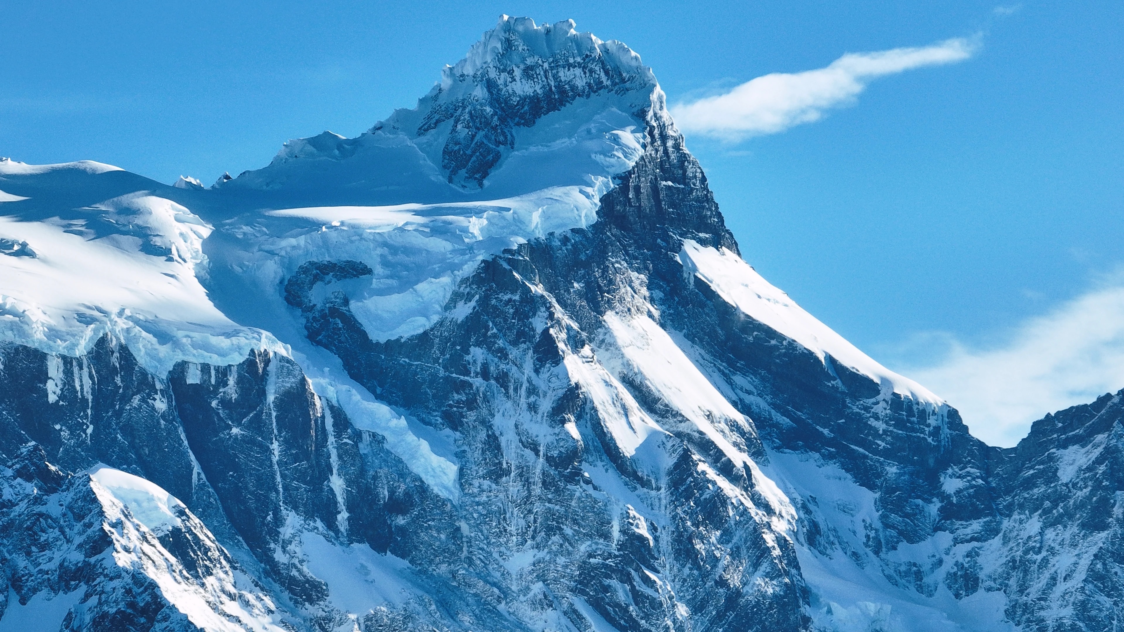
Torres del Paine National Park is, for many travellers, the reason to come to Chile. The three granite towers, soaring pillars of rock that glow pink at sunrise, are the park's iconic image, but they are only the beginning. The park encompasses an entire mountain massif surrounded by electric-blue lakes, hanging glaciers, guanaco-roamed grasslands, and forests of lenga beech that turn gold in autumn.
The W Trek, a 4–5 day circuit that visits the towers, the French Valley, and the Grey Glacier, is one of the world's most famous multi-day hikes, while the full O Circuit (7–9 days) encircles the entire massif through wilderness that few visitors see.
Grey Glacier, an arm of the Southern Patagonian Ice Field, calves icebergs into Lago Grey that drift past kayakers and catamaran passengers in an ever-changing blue sculpture garden. The park is home to pumas, Andean condors, foxes, and one of the healthiest guanaco populations on the continent.
Punta Arenas, Gateway to Antarctica
Punta Arenas, the regional capital, is the southernmost city of its size in the world, a wind-battered port of 130,000 people overlooking the Strait of Magellan that separates the South American mainland from Tierra del Fuego. Founded as a penal colony and coaling station in 1848, it grew wealthy during the sheep-ranching boom of the late 19th century, and the grand mansions along the Plaza de Armas, particularly the Palacio Sara Braun, attest to the fortunes made by Patagonian wool barons.
Today, Punta Arenas is the departure point for Antarctic expedition cruises, with vessels heading south through the Drake Passage to the white continent.
The city's Cementerio Municipal, with its cypress-lined avenues and elaborate mausoleums, is considered one of the most beautiful cemeteries in the Americas. Nearby, the Magdalena Island penguin colony, 60,000 breeding pairs of Magellanic penguins, is a short ferry ride away.
Tierra del Fuego, The End of the Earth
Across the Strait of Magellan, the Chilean half of Tierra del Fuego is a wind-swept expanse of grassland, peat bog, and the southernmost forests on the planet. Porvenir, the island's main settlement, is a quiet town of tin-roofed houses and a gold-rush history, where Chilean and Croatian immigrant cultures blend in a frontier atmosphere.
The island's interior harbours vast estancias where sheep outnumber people by orders of magnitude, and the king penguin colony at Bahía Inútil, the only significant king penguin colony on mainland South America, is one of the region's most extraordinary wildlife experiences.
At the island's southern tip, the Parque Karukinka, established by the Wildlife Conservation Society, protects the last intact forests of Tierra del Fuego, ancient lenga and coigüe trees that shelter the endangered culpeo fox, Patagonian woodpeckers, and the elusive huemul deer.
Glaciers, Fjords, and the Ice Fields
The Magallanes Region contains the Southern Patagonian Ice Field, at 13,000 square kilometres, the world's third-largest reserve of fresh water after Antarctica and Greenland. Its glaciers pour down through the Andes into fjords and lakes that are among the most spectacular waterscapes on Earth. The Grey, Tyndall, and Balmaceda glaciers are accessible from Torres del Paine and Puerto Natales, while the more remote Pío XI Glacier, the largest in the Southern Hemisphere outside Antarctica, can only be reached by multi-day boat expeditions through the fjords.
The channels of Última Esperanza ('Last Hope Sound') are home to humpback whales, leopard seals, and Commerson's dolphins, and the boat trip from Puerto Natales to the Balmaceda and Serrano glaciers passes through scenery of staggering grandeur.
The Bernardo O'Higgins National Park, Chile's largest protected area, encompasses much of this ice field and its surrounding wilderness, a region so vast and inaccessible that large portions remain unexplored.
Patagonian Culture, Wind, Wool, and Asado
Life in Magallanes is shaped by the elements: the relentless Patagonian wind that bends trees horizontal, the long winter darkness, and the brief but luminous summers when the sun barely sets. This harsh environment has forged a distinctive culture of self-reliance, warmth, and dark humour. The estancias, many still operating as working sheep ranches, offer an authentic window into this world: visitors can participate in sheep shearing, horseback roundups, and the preparation of the legendary Patagonian asado al palo, where an entire lamb is splayed on a metal cross and slow-roasted over an open fire for hours.
In Puerto Natales, the charming gateway town to Torres del Paine, restaurants serve centolla (king crab) pulled from the fjords that morning, accompanied by calafate berry desserts, the calafate being a native bush whose berries, according to local legend, ensure that anyone who eats them will return to Patagonia.
Few who visit would disagree.
Points of Interest
Cities
Cities
Puerto Natales
Western gateway to Parque Nacional Torres del Paine and the launching point for Patagonian fjord cruises, Puerto Natales sits on Última Esperanza Sound 250 km north of Punta Arenas. The town began as a sheep-ranching outpost in the 1880s; its old Frigorífico Bories cold-store complex, now a museum, is the largest surviving industrial monument in Chilean Patagonia. Today its waterfront, lined with hostels and outfitters, is the staging area for the 'W' and 'O' treks through Torres del Paine.
Cities
Punta Arenas
Capital of Magallanes and largest city in Chilean Patagonia, founded in 1848 as a penal colony on the Strait of Magellan. Punta Arenas grew rich on the late-nineteenth-century wool boom, leaving behind the European-style mansions of the Sara Braun and Menéndez families around Plaza Muñoz Gamero. Today it is the embarkation point for Antarctic expeditions and the cruise route to Cape Horn, and its Cementerio Municipal is considered one of the most striking historic cemeteries in South America.
Cities
Porvenir
Capital of the Chilean side of Tierra del Fuego, founded during the 1880s gold rush as miners poured into the island. Porvenir sits across the Strait of Magellan from Punta Arenas, reached by a two-hour ferry from Bahía Chilota or a longer crossing from Punta Delgada. The town's small Croatian community, descendants of immigrant miners, is commemorated in the Museo Fernando Cordero Rusque, and Bahía Inútil to the south hosts one of the largest king penguin colonies outside Antarctica.
Cities
Puerto Williams
Southernmost permanently inhabited settlement in the world, on Isla Navarino south of the Beagle Channel. Founded in 1953 as a Chilean naval base to assert sovereignty against Argentina's Ushuaia across the channel, Puerto Williams remains the seat of Cabo de Hornos Province. The town is the access point for the Dientes de Navarino trek and the last waypoint for yachts bound for Cape Horn or the Antarctic Peninsula.
Natural Reserves
Natural Reserves
Parque Nacional Bernardo O'Higgins
Chile's largest national park at 3.5 million hectares, covering most of the Southern Patagonian Ice Field and the maze of fjords running north into Aysén. The park contains 49 glaciers — including Pío XI, the largest non-polar glacier in the southern hemisphere — and is accessed only by boat from Puerto Natales or Puerto Edén.
Natural Reserves
Parque Nacional Kawésqar
Created in 2019 by upgrading the former Alacalufes National Reserve, Kawésqar covers 2.8 million hectares of fjords, channels and ice fields west of Puerto Natales. The park is named for the Kawésqar, canoe-faring nomads who navigated these waters for at least 6,000 years and whose last fluent speakers still live in Puerto Edén.
Natural Reserves
Cueva del Milodón
A 200-metre limestone cave 24 km north of Puerto Natales where, in 1895, a German settler discovered a piece of mylodon hide — the partly mummified skin of a giant ground sloth that lived here at the end of the Ice Age. The find triggered international fossil expeditions and is referenced in Bruce Chatwin's 'In Patagonia'. A life-size mylodon statue stands at the cave entrance.
Natural Reserves
Glaciar Serrano
Tidewater glacier in the Southern Patagonian Ice Field, reached by a half-day boat journey up Última Esperanza Sound and the Río Serrano from Puerto Natales. The trip threads past calving icebergs and the towering Cerro Balmaceda before arriving at a small landing on the glacier's face.
Natural Reserves
Glaciar Grey
Twelve-kilometre-wide glacier flowing east off the Southern Patagonian Ice Field into Lago Grey, on the western edge of Torres del Paine. Icebergs calved from its face drift across the lake to a black-sand beach at its eastern end. Catamaran tours from Hostería Lago Grey navigate among the floes, and the glacier marks the second day of the 'W' trek.
Natural Reserves
Parque Nacional Torres del Paine
Chile's most celebrated national park (242,000 hectares), centred on the three granite spires of the Paine Massif rising 2,800 m above the Patagonian steppe. The 'W' and 'O' treks circling the massif have become the most famous multi-day hikes in South America. Inside the park: Grey Glacier flowing off the Southern Patagonian Ice Field, the milky-blue Lago Pehoé, and herds of guanacos that recovered after pumas drove them back from the brink.
Natural Reserves
Parque Nacional Pali Aike
Volcanic steppe park 200 km north-east of Punta Arenas, on the Chilean–Argentine border. Pali Aike means 'devil's country' in the Tehuelche language: the moonscape of cinder cones, lava flows and pampa is dotted with caves where some of the oldest human remains in the Americas (10,000+ BP) have been excavated.
Natural Reserves
Reserva Nacional Magallanes
A 20,000-hectare reserve right at the back door of Punta Arenas, protecting Lenga forest and the watersheds of the Río de las Minas. Trails climb to the Cerro Mirador viewpoint and the small Andino Club ski centre — the southernmost in continental South America.
Natural Reserves
Isla Magdalena
A treeless 85-hectare island in the Strait of Magellan, two hours by boat from Punta Arenas, hosting a colony of about 120,000 Magellanic penguins between October and March. A clearly-marked boardwalk threads through the burrows; the rest of the island is closed to protect the nesting birds.
Natural Reserves
Parque Pingüino Rey
Private 4,000-hectare reserve on Bahía Inútil in north-central Chilean Tierra del Fuego, protecting the only king-penguin colony on the South American continent — about 60 birds that returned to the bay in 2010 after a century of being hunted nearly to extinction. A short boardwalk skirts the colony at a respectful distance; visits are by guided tour, and the king penguins are present year-round with chicks visible from late summer.
Natural Reserves
Parque Karukinka
297,000-hectare conservation park covering the southern half of Chilean Tierra del Fuego, managed by the Wildlife Conservation Society after Goldman Sachs donated the land in 2004. Karukinka, which means 'our land' in the Selk'nam language, protects sub-Antarctic forests, peatlands and the largest guanaco population in southern Chile.
Natural Reserves
Isla Santa Inés
Large remote island west of Tierra del Fuego, draped in southern Patagonian rainforest and capped by the De Agostini ice field. Inhabited only by occasional crab fishermen, the island is accessible mainly by expedition cruise and remains one of the least-visited corners of Chilean Patagonia.
Natural Reserves
Parque Nacional Alberto de Agostini
Vast 1.46-million-hectare park covering the Cordillera Darwin range and a maze of southern Tierra del Fuego fjords, named for the Italian Salesian priest who first explored and mapped the area in the early twentieth century. Accessible only by sea, the park's tidewater glaciers — including the Pía and Garibaldi — are highlights of cruise itineraries from Punta Arenas to Ushuaia.
Natural Reserves
Parque Nacional Cabo de Hornos
Southernmost national park in the world, covering Isla Hornos and the surrounding archipelago at the convergence of the Pacific and Atlantic oceans. Cape Horn, the rocky headland that marks the navigational southern tip of the Americas, has been a UNESCO Biosphere Reserve since 2005 for its sub-Antarctic mossy forests, peat bogs, and the only known species-rich miniature flora in the world.