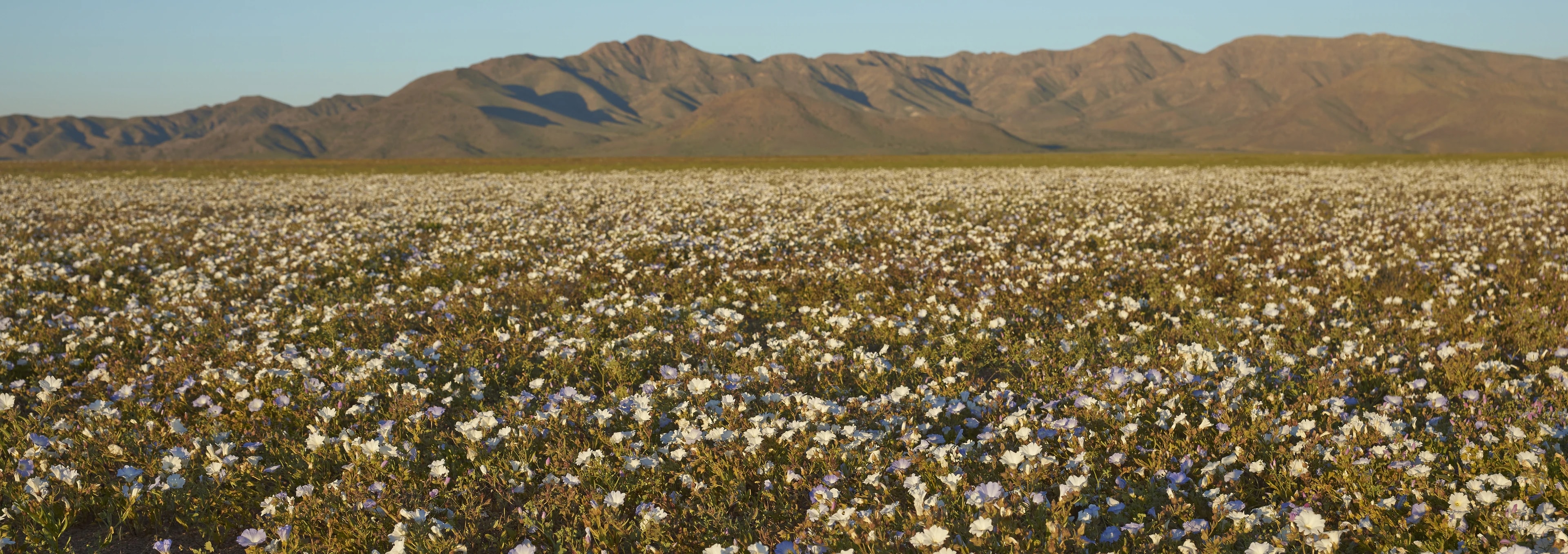
The Atacama Region is perhaps best known for the desierto florido, the flowering desert, when rare rainfall transforms barren plains into carpets of pink, white, and violet wildflowers. Copiapó, the capital, sits in a green valley surrounded by some of Earth's most extreme landscapes, from pristine beaches at Bahía Inglesa to volcanoes above 6,000 metres.
Every few years, when El Niño or unusual Pacific weather patterns bring rain to the normally bone-dry Atacama, something miraculous happens. Seeds that have lain dormant in the soil for decades suddenly germinate, and within weeks the barren brown plains erupt in vast carpets of wildflowers, pink pata de guanaco, white añañucas, violet malvillas, and over 200 other species, many of them endemic.
The desierto florido, or flowering desert, typically occurs between September and November and is most spectacular in the coastal hills between Vallenar and Copiapó, where the camanchaca fog provides just enough moisture to supplement the rain.
In superbloom years, the phenomenon draws tens of thousands of visitors and has become one of Chile's most iconic natural spectacles. Scientists study the event for insights into seed dormancy and climate adaptation, while local communities celebrate with festivals and guided wildflower walks.
The coast of the Atacama Region hides one of Chile's best-kept secrets: beaches with water so clear and turquoise that first-time visitors compare them to the Caribbean. Bahía Inglesa, named by English pirates who sheltered in its calm bay centuries ago, offers a string of crescent coves with white sand and water that is surprisingly warm for Chile's Pacific coast, thanks to a local divergence in the cold Humboldt Current.
Nearby Playa La Virgen and Pan de Azúcar National Park add dramatic coastal cliffs, cactus-covered hillsides, and colonies of Humboldt penguins, sea otters, and bottlenose dolphins.
The coastal town of Caldera preserves Victorian-era railway architecture from its days as a copper-shipping port, and its fish market serves some of the freshest seafood on the northern coast, grilled reineta, ceviche de cojinova, and empanadas de mariscos eaten on the pier.
The Copiapó Valley has been synonymous with mining since the Spanish colonial period, when silver strikes at Chañarcillo and the discovery of rich copper veins transformed the region into Chile's economic engine. The city of Copiapó itself, the regional capital, sits in a narrow green valley fed by a river that often runs dry before reaching the sea, yet it supports vineyards that produce the northernmost Chilean wines and olive groves that date back centuries.
The Mineralogical Museum houses specimens from the region's storied mining past, while the Railway Museum preserves the locomotive from South America's first railway line, which ran from Copiapó to the port of Caldera in 1851.
In 2010, the nearby San José mine gained worldwide attention when 33 miners were rescued after 69 days trapped underground, a survival story that became a symbol of Chilean resilience.
East of Copiapó, the Andes rise to some of the highest peaks outside the Himalayas. Ojos del Salado, at 6,893 metres, is the world's tallest volcano and the second-highest summit in the Americas, attracting mountaineers who tackle its remote approach through a landscape of salt flats, coloured lagoons, and fumaroles.
Nearby, the Nevado Tres Cruces National Park protects the Laguna Santa Rosa and Laguna del Negro Francisco, high-altitude lakes ringed by flamingos and backed by snow-dusted peaks, along with vast colonies of viscachas and vicuñas. The road to these sites passes through the abandoned mining settlement of Mina Refugio and crosses the Paso San Francisco to Argentina, one of the highest border crossings on Earth.
For those who prefer their altitude in smaller doses, the hot springs of Baños del Toro and Termas de Río Negro offer thermal relaxation at a more manageable 3,000 metres.
Before the Spanish arrived, the Atacama Region was home to the Diaguita people, whose distinctive geometric pottery, characterised by complex interlocking patterns in black, white, and red, represents one of pre-Columbian Chile's highest artistic achievements. Archaeological sites throughout the Huasco and Copiapó valleys reveal a civilisation that practiced sophisticated irrigation, cultivated maize and quinoa, and maintained trade links stretching from the coast to the Andes and beyond to the Argentine pampas.
Today, Diaguita communities are experiencing a cultural revival, with artisans reproducing traditional ceramic designs and communities gaining formal recognition as indigenous peoples.
The region's dark, dry skies have also made it a rising star in astrotourism: observatories like Cruz del Sur near Combarbalá offer telescope nights, and several lodges in the Huasco Valley provide astronomer-guided sessions where the southern Milky Way blazes overhead with astonishing clarity.
Historic port town of around 18,000 on Chile's northern coast, founded in 1850 as the Pacific terminus of South America's first railway (the 81 km Copiapó–Caldera line, built to carry silver ore down from the mountains). The station house survives as the local museum, and the wooden Iglesia de San Vicente is an unusual example of 19th-century Chilean pine architecture. Today Caldera is a summer beach town for Copiapó, with a lively fishing caleta serving scallops and machas straight off the boats.
Capital of the Atacama Region (population around 160,000), founded in 1744 in an oasis of the Copiapó River between the Atacama Desert and the Andes. Copiapó boomed from the 1830s onwards after Juan Godoy struck one of the world's richest silver veins at nearby Chañarcillo, and again through the 20th century as a hub for copper and iron mining; it is best known to the wider world for the 2010 rescue of the 33 Los Pelambres miners trapped 700 m underground. The historic centre keeps a neoclassical cathedral, several palacios of the mining era, and the country's oldest mining school, now part of the Universidad de Atacama.
Coastal town of about 10,000 at the mouth of the Huasco River, roughly 55 km west of Vallenar. A working fishing port and small iron-ore terminal, Huasco is also the northern gateway to Parque Nacional Llanos de Challe and to the famous desierto florido bloom that carpets the surrounding hills after rainy winters. The seafront has a modest fishing caleta serving fresh ceviche and paila marina, and there is a small pisco-and-wine tradition in the Huasco Valley inland that predates the more famous Elqui.
Informal fishing hamlet on the coast about 40 km south of Caldera, built from painted wood and reclaimed materials by generations of squatting families and Copiapó holidaymakers. Puerto Viejo has no paved streets and only intermittent services, but its wide protected bay with turquoise water has made it one of the most-loved beach spots in the Atacama Region.
Provincial capital of the Huasco Valley (population around 55,000), founded in 1789 as Villa San Ambrosio de Ballenary by governor Ambrosio O'Higgins, who named it after his birthplace in Ireland (Ballenary → Vallenar). The town sits at the meeting point of the coastal desert and the greener Huasco Valley, where olives, table grapes, papayas and small vineyards produce a distinctive high-desert style of pisco. Vallenar is a common base for trips to Parque Nacional Llanos de Challe and, in wet years, for hunting the huge fields of desierto florido that spread across the hills to the north.
Small beach resort about 6 km south of Caldera, famous within Chile for the clear turquoise water of its sheltered coves and for the powdery white sand of Playa La Piscina. Bahía Inglesa ("English Bay") is said to owe its name to English pirates who used the anchorage in the 17th century; today the shoreline is lined with low-rise seafood restaurants, small hotels, and a shellfish industry that supplies scallops and abalone across the country.
Open all year
beach · Restaurant
45,000-hectare coastal park north of Huasco, protecting one of the strongest expressions of the desierto florido — the mass bloom of desert flowers that follows rare rain events in the Atacama. In the best years the coastal steppe turns violet, yellow and white with añañucas, garras de león and pata de guanaco. Beyond the bloom, the park offers a wild Pacific coastline with sea lions and grey foxes, and a short trail up Cerro Blanco.
Open all year · CLP 5,000
Hiking · Wildlife · beach
High-altitude park east of Copiapó covering roughly 59,000 hectares of altiplano at 3,700–4,500 m, built around the volcanoes of Nevado de Tres Cruces (6,749 m) and Nevado del Ojos del Salado's western flanks. The park contains the emerald-and-turquoise Laguna Santa Rosa and Laguna del Negro Francisco, both critical breeding sites for the three Andean flamingo species; guanacos, vicuñas and Andean condors round out the wildlife. Access is by 4x4 only from Copiapó via the Ruta 31 mountain pass.
Open all year · CLP 5,000
Hiking · Wildlife
At 6,893 m, Ojos del Salado is the highest volcano on Earth and the second-highest peak in the Americas after Aconcagua. It sits on the Chile–Argentina border east of Copiapó, in an ochre high-altitude desert dotted with brilliant blue crater lakes; the world's highest permanent lake (about 6,390 m) lies just below the summit. Climbs are done between December and March from the Atacama refuges Murray and Tejos, and require both altitude acclimatisation and a permit from Difrol.
Open all year (climb season Dec–Mar)
Hiking
44,000-hectare coastal park straddling the border between Antofagasta and Atacama regions, 30 km north of Chañaral. The park protects an unusually diverse stretch of Atacama coast: sheltered coves and long empty beaches on one side, cactus-dotted coastal cordillera on the other, and offshore, the small rocky Isla Pan de Azúcar, home to a colony of Humboldt penguins along with sea lions, otters and Guanay cormorants. Boat trips to the island depart from Caleta Pan de Azúcar; on land, a short trail up Mirador Pan de Azúcar gives a panoramic view of the coast.
Daily 8:30–20:00 · CLP 5,000
Hiking · Wildlife · beach · Boat tours
Isolated white-sand beach about 90 km south of Caldera, reached by a rough gravel spur off the Panamericana. Playa La Virgen sits inside a small semi-circular bay of exceptionally clear turquoise water, sheltered by rocky headlands; a private concession runs a summer campsite with basic services (December–March). Outside the season it is often completely empty.
Open all year
beach · Camping