The Antofagasta Region is where the driest desert on Earth meets some of the clearest skies in the universe. Home to the ALMA radio telescope array and world-class observatories, it is a pilgrimage for astronomers and stargazers alike. San Pedro de Atacama is the adventure hub for volcano treks, flamingo lagoons, and the surreal Moon Valley.
Nestled at 2,400 metres in an oasis at the edge of the Salar de Atacama, San Pedro de Atacama has transformed from a dusty adobe village into South America's premier desert adventure destination. Its single-storey mud-brick streets, refreshingly free of high-rises by local building code, are lined with tour agencies, craft-beer bars, and international restaurants, all catering to the steady stream of backpackers, photographers, and astronomers drawn by the region's extreme landscapes.
From here, day trips radiate in every direction: sandboarding down the dunes of Valle de la Muerte, cycling to the ancient pukará fortress of Quitor, floating in the salt-saturated Laguna Cejar, or watching sunset paint the eroded rock formations of the Moon Valley in shades of amber, rose, and violet.
The town is also the staging point for some of the continent's highest volcano ascents.
At 4,320 metres above sea level, the El Tatio geyser field erupts at dawn with over 80 active geothermal vents sending columns of steam into the freezing morning air, the third-largest geyser field on Earth and the highest. Visitors arrive in darkness to watch the spectacle at sunrise, then warm up in natural hot spring pools while vicuñas graze in the foreground.
South of San Pedro, the Salar de Atacama stretches for over 3,000 square kilometres, its crusty white surface broken by turquoise brine pools where thousands of flamingos feed on tiny brine shrimp. Further south, the Miscanti and Miñiques lagoons sit in volcanic craters at nearly 4,200 metres, their deep blue waters framed by copper-coloured peaks.
The Tara salt flat, accessible only by 4x4, shelters the bizarre rock pinnacles of the Monjes de la Pacana, natural stone columns that resemble hooded monks standing sentinel on the altiplano.
The Atacama Desert's combination of extreme aridity, high altitude, and minimal light pollution has made the Antofagasta Region the global epicentre of ground-based astronomy. The ALMA (Atacama Large Millimeter Array) observatory, at 5,000 metres on the Chajnantor plateau, is the world's most powerful radio telescope, a collaboration of 66 antennas probing the origins of stars, planets, and galaxies.
Nearby, the European Southern Observatory operates the Paranal complex, home to the Very Large Telescope, whose four 8. 2-metre mirrors have captured images of exoplanets and distant black holes.
For amateur stargazers, San Pedro offers nightly telescope tours where the Milky Way arches overhead with a brilliance that is genuinely life-changing. The region will soon host the Extremely Large Telescope, whose 39-metre mirror will be the largest optical telescope ever built.
Beneath the desert's barren surface lies extraordinary mineral wealth. Chuquicamata, just outside the city of Calama, was for decades the world's largest open-pit copper mine, a terraced crater over 4 kilometres long and 850 metres deep, now transitioning to underground extraction. The region produces a significant share of the world's copper and is increasingly central to the global lithium supply, with vast brine deposits beneath the Salar de Atacama feeding the batteries of electric vehicles worldwide.
The mining city of Antofagasta, the regional capital, has grown into a modern port hub with upscale restaurants, ocean-front boardwalks, and the iconic La Portada, a natural stone arch rising from the Pacific that has become the city's symbol.
Mining heritage tours take visitors through the abandoned camps and railways that once connected the desert to the coast.
Long before the mining booms, the Atacama Desert supported complex civilisations. The Atacameño (Lickanantay) people built irrigated villages, terraced hillside farms, and trade networks spanning from the Pacific to the jungle lowlands of present-day Argentina and Bolivia. The R.P. Gustavo Le Paige Archaeological Museum in San Pedro houses one of the finest pre-Columbian collections in Chile, including ceremonial tablets, gold ornaments, and textiles that reveal sophisticated artistic and spiritual traditions.
Today, Atacameño communities in villages like Toconao, Socaire, and Machuca maintain ancestral practices, from irrigation channels that date to pre-Inca times to the harvest festival of Limpia de Canales, where entire communities gather to clean and bless the ancient waterways.
The region's cuisine blends these traditions with desert ingredients: rica-rica herb, chañar fruit syrup, and slow-cooked camelid meats prepared in earth ovens.
Northern Chile's largest city (around 380,000) and the port through which most of the country's copper leaves for the world. Founded in 1866, it belonged to Bolivia until the War of the Pacific and still carries that layered history in its British-era waterfront and the Huanchaca ruins, a vast silver refinery abandoned above the bay. It sits on one of the driest coastlines on Earth, where measurable rain can skip years at a time.
Mining city of about 180,000 on the Loa, Chile's longest river, sitting at 2,260 m in the middle of the desert. It exists largely to serve Chuquicamata, for decades the largest open-pit copper mine in the world, whose company town was evacuated in 2007 and now stands empty a few kilometres north. For travellers it is mostly the airport and the road east to San Pedro de Atacama.
Port town of roughly 14,000 on a deep natural bay 60 km north of Antofagasta, sheltered enough that it has become one of the country's main industrial harbours. Thermoelectric plants and bulk terminals line the shore, while the headlands and offshore rocks still hold Humboldt penguins, sea lions and cormorants. The bay's cold, nutrient-rich water is what draws both the wildlife and the fishing fleet.
Adobe village of around 11,000 at 2,400 m that has become the tourist heart of the Atacama, framed by the near-perfect cone of Licancabur. Its narrow earthen streets hold the 18th-century Iglesia de San Pedro and the archaeological collection assembled by the Belgian priest Gustavo Le Paige, whose work first documented the region's Likan Antai heritage. Almost every major desert sight — Valle de la Luna, El Tatio, the salares and altiplano lagoons — is reached from here.
A saltpetre town built in 1924 and abandoned in 1940 when synthetic nitrates destroyed the industry, leaving streets, a theatre and worker housing standing in the open desert. In 1973 the site was repurposed as a political prison under the military government, and the minefield laid around it was only fully cleared decades later. It is preserved today as a national monument and a memorial to both histories.
Daily 10:00–17:00 · CLP 3,000
Tours · Parking
The largest geyser field in the southern hemisphere, sitting at 4,320 m in a bowl ringed by volcanoes about 90 km north of San Pedro. Some eighty geysers and fumaroles vent at dawn, when the cold air turns each jet into a column of steam; by mid-morning the show has largely faded. Visitors leave San Pedro around 05:00 and should expect sub-zero temperatures and the effects of altitude.
Daily 06:00–13:00 · CLP 15,000
Hiking · Thermal baths · Parking
A sinkhole lagoon in the northern Salar de Atacama whose salinity rivals the Dead Sea, dense enough that swimmers float without effort. The water sits an improbable turquoise against the white salt crust, with Licancabur on the horizon. Bathing is restricted to protect the fragile crust, and rinsing showers are provided at the entrance.
Daily 09:00–18:00 · CLP 30,000
Swimming · Parking
The most accessible sector of the Salar de Atacama and the easiest place in Chile to see three flamingo species — Andean, Chilean and James's — feeding in the shallows. A short marked circuit crosses a jagged crust of salt formations; sunset, when the birds silhouette against the Andes, is the classic visiting hour. It forms part of the Los Flamencos National Reserve and is managed with the local Atacameño community of Toconao.
Daily 08:00–19:00 · CLP 8,000
Wildlife · Parking
Also called the Lagunas Escondidas, a chain of seven small hypersaline lagoons hidden in the salt crust west of San Pedro, reached by a rough track across open desert. Only one is open for floating; the rest are left undisturbed. Their isolation makes for a far quieter experience than the better-known Cejar.
Daily 09:00–17:00 · CLP 15,000
Swimming · Parking
Twin altiplano lakes at about 4,200 m, held in a basin below the Miñiques volcano and separated by a lava flow that once split a single larger lake in two. Their deep blue against ochre slopes is among the most photographed sights of the puna, and the shores draw vicuñas, Andean gulls and giant coots. Access is via a short loop trail; swimming is not permitted.
Daily 09:00–17:00 · CLP 8,000
Hiking · Wildlife · Viewpoint
A natural stone arch standing offshore 18 km north of Antofagasta, cut from marine sediment on a volcanic base by the constant swell of the Pacific. It is among the most recognisable landmarks of northern Chile and appears on postcards, coins and stamps. A clifftop viewpoint and restaurant overlook the arch; the beach below is closed because of rockfall.
Tue–Sun 09:30–19:00 · Free
Viewpoint · Restaurant · Parking
A coastal monument protecting a rare pocket of fog-dependent desert vegetation, where the camanchaca rolling in off the Pacific supports cacti, bromeliads and endemic plants found nowhere else. The site also holds archaeological traces of the Changos, the fisher people who worked this coast for millennia. It is remote and lightly visited, with no facilities.
Open all year · Free
Hiking · Wildlife
A museum of the nitrate era in the desert interior, telling the story of the oficinas salitreras whose exports funded much of Chile through the late nineteenth and early twentieth centuries. Exhibits cover the extraction process, the pampinos who worked the pampa, and the company scrip that replaced wages. The collapse of the industry after synthetic nitrates left dozens of ghost towns across this stretch of the Atacama.
Daily 09:00–18:00 · CLP 3,000
Tours · Parking
A shoreline of iron-stained red rock on the Salar de Aguas Calientes, roughly 4,000 m up on the way to the Argentine border. The oxidised boulders sit against pale salt and startlingly blue water, a colour combination that has made the site one of the region's signature images. It lies within Los Flamencos and is usually combined with Miscanti and Miñiques in one long day from San Pedro.
Daily 09:00–17:00 · CLP 15,000
Viewpoint · Parking
A high-altitude park around the 6,739 m Llullaillaco volcano on the Argentine border, one of the most extreme protected areas in Chile. The summit holds Inca ceremonial platforms among the highest archaeological sites in the world, and the surrounding puna supports vicuñas, foxes and Andean flamingos at the salt flats below. Access requires a permit, a 4x4 and full self-sufficiency.
Restricted access · Permit required
Hiking · Wildlife
A reserve of some 74,000 hectares split across seven separate sectors around San Pedro de Atacama, protecting salt flats, altiplano lagoons and eroded desert terrain rather than one continuous area. Its sectors include Valle de la Luna, Laguna Chaxa, Miscanti and Miñiques, and the Tara salt flat. It is co-managed with Atacameño communities, several of which run the individual sites.
Daily 08:00–19:00 · CLP 8,000
Hiking · Wildlife · Viewpoint
A park on the Mejillones peninsula protecting the coastal massif of the same name, where fog condensing on the slopes sustains isolated relict vegetation in an otherwise absolute desert. Trails climb from the shore toward viewpoints over the Pacific and the peninsula's cliffs. It is one of Chile's newest national parks and remains lightly developed.
Open all year · Free
Hiking · Viewpoint
A large high-altitude reserve in the upper Loa basin, north-east of Calama, taking in wetlands, thermal springs and puna grassland between roughly 3,000 and 5,000 m. It protects vicuñas, flamingos and the bofedales — high Andean peat wetlands — that sustain them, alongside Atacameño herding communities who have used these pastures for generations.
Open all year · Free
Wildlife · Hiking
A small reserve immediately north of Antofagasta, set up to protect a fragment of fog-fed coastal desert vegetation on the hills above the city. The camanchaca that rolls in most mornings sustains cacti and seasonal flowering plants a short drive from the urban edge. Its proximity makes it the most accessible protected area in the region.
Open all year · Free
Hiking · Wildlife
A remote high-altitude salt flat at around 4,300 m near the Bolivian border, reached over rough tracks through the Andean puna. Beyond the flat itself stand the Monjes de la Pacana, wind-carved volcanic pillars rising from the plain, and lagoons that gather flamingos and vicuñas. Its isolation keeps visitor numbers low and makes a guided 4x4 trip effectively mandatory.
Daily 09:00–17:00 · CLP 8,000
Hiking · Wildlife · Viewpoint
Eight terraced thermal pools strung along a canyon 30 km north of San Pedro, fed by water emerging at a steady 25–30 °C and framed by reed beds in an otherwise bare gorge. Wooden walkways connect the pools, which sit at about 3,500 m. Numbers are capped and tickets are best booked ahead.
Daily 09:30–17:30 · CLP 25,000
Thermal baths · Parking
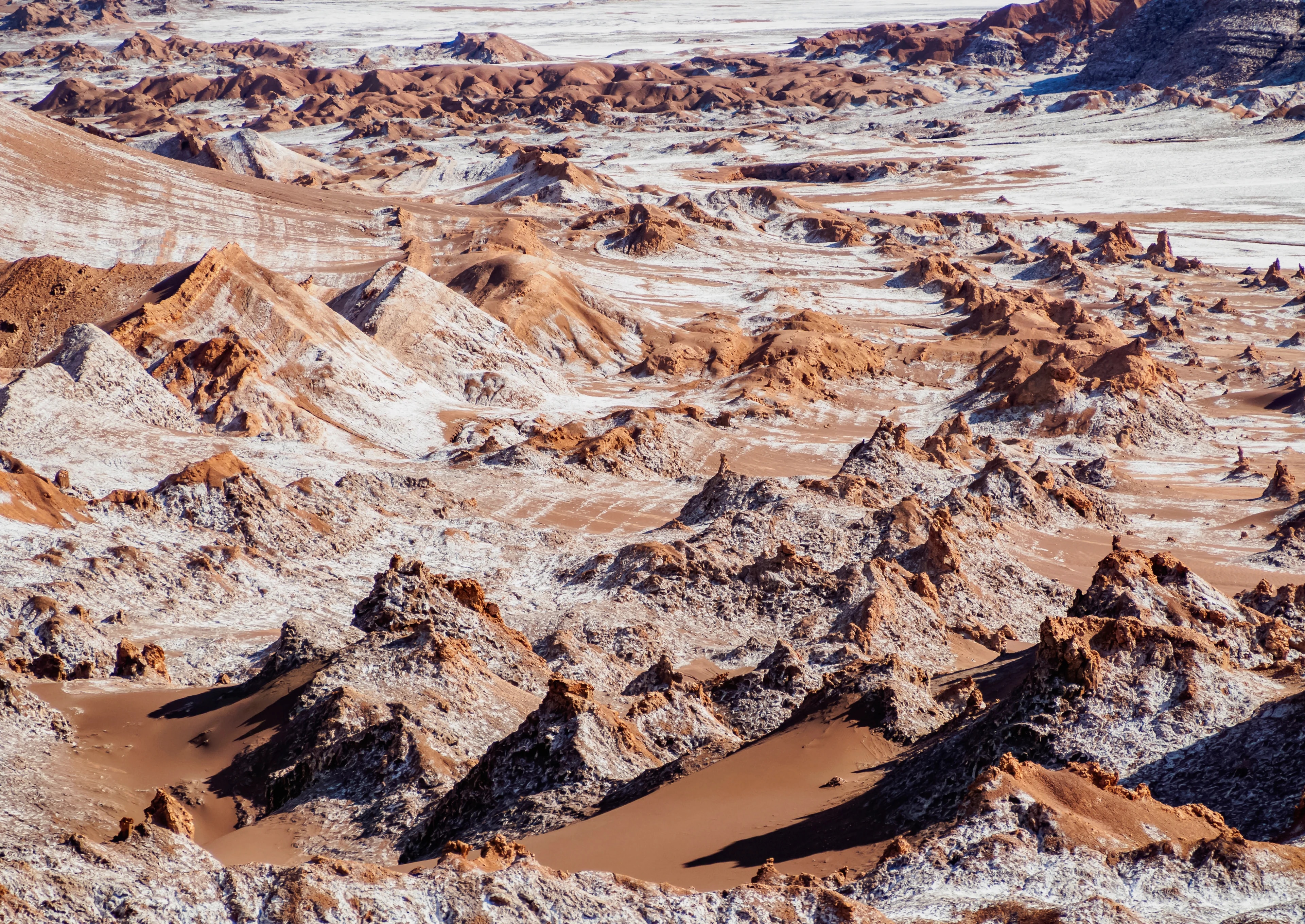
A basin of eroded salt and clay in the Cordillera de la Sal, 13 km west of San Pedro, whose ridges, dunes and caverns were named for a resemblance to lunar terrain that NASA once used it to test rover prototypes against. The Duna Mayor viewpoint at sunset is the classic vantage, when the rock runs through orange and violet. It falls within the Los Flamencos National Reserve and access is regulated.
Daily 09:00–20:00 · CLP 10,000
Hiking · Viewpoint · Parking
A valley about 90 km north-east of San Pedro where mineral-rich sediments — copper greens, iron reds, sulphur yellows and clay whites — stripe the hillsides in bands. The colours come from the same volcanic and hydrothermal activity that mineralised the region. Nearby are the Hierbas Buenas petroglyphs, carved by caravan traders who crossed here for centuries.
Daily 09:00–18:00 · CLP 10,000
Hiking · Viewpoint
The Atacama Large Millimeter/submillimeter Array: 66 high-precision radio antennas spread across the Chajnantor plateau at about 5,000 m, where the air is thin and dry enough for millimetre-wave astronomy. Built as a partnership between Europe, North America and East Asia, it is the largest ground-based astronomical project ever undertaken and observes the cold universe of gas, dust and forming planetary systems. Free weekend visits run to the Operations Support Facility at 2,900 m, not to the array itself, which sits too high for casual visitors.
Saturday & Sunday tours, by reservation
Tours · Parking
Small tourist observatory near the oasis village of Chiu-Chiu in the Loa valley, north-east of Calama. It offers guided night sessions under some of the darkest skies in the Antofagasta Region, far from the light domes of Calama and the mining camps. Visits are by prior arrangement and depend on the lunar cycle.
By reservation
Tours · Stargazing
Observatory of the Universidad de Antofagasta, inaugurated in 2018 in the desert interior near Baquedano, notable as an observing facility owned and run by a Chilean university rather than an international consortium. It supports both research and student training, and opens for organised visits by arrangement.
By reservation
Tours · Stargazing
The European Southern Observatory's flagship site, home to the Very Large Telescope: four 8.2 m unit telescopes plus four movable auxiliaries on a flattened summit at 2,635 m. The mountain was chosen for having among the clearest, driest skies on the planet, and the array's units can be combined interferometrically to resolve detail no single mirror could reach. The angular concrete Residencia where staff live doubled as a villain's lair in the Bond film Quantum of Solace; free public tours run on Saturdays by advance booking.
Saturday tours, by reservation
Tours · Parking