ExploreChilewir leben unvergessliche Abenteuer


← Alle Regionen
Magallanes y Antártica Chilena
Das Ende der Welt, und der Anfang der Antarktis. Die Region Magallanes umfasst den Nationalpark Torres del Paine, dessen Granittürme und Gletscher zu den meistfotografierten Landschaften der Erde gehören. Punta Arenas blickt auf die Magellanstraße und ist Ausgangshafen für Antarktis-Kreuzfahrten.
Audioversion verfügbar
Torres del Paine, Kathedrale Patagoniens
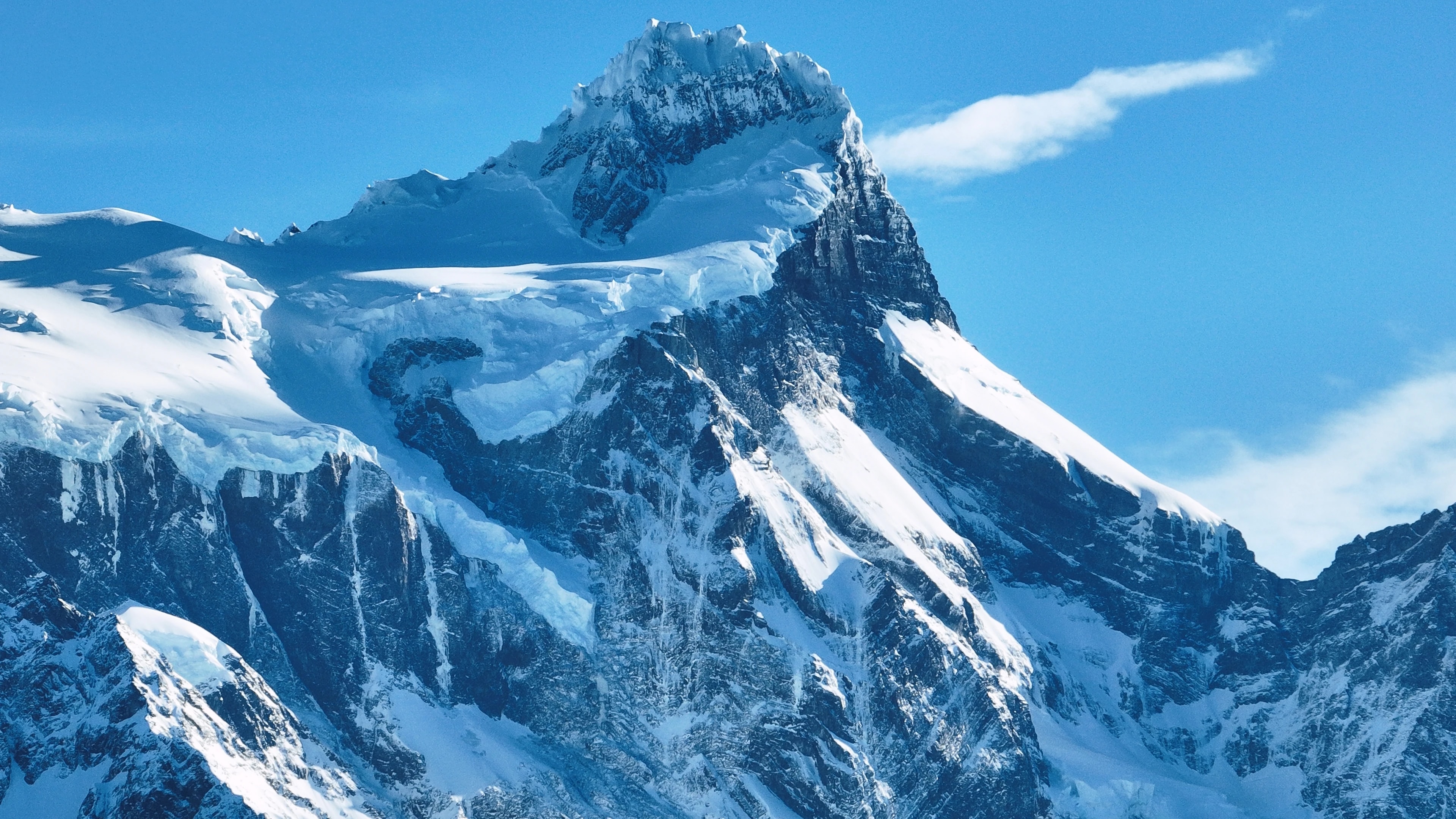
Der Nationalpark Torres del Paine ist für viele Reisende der Grund, nach Chile zu kommen. Die drei Granittürme, aufragende Felssäulen, die bei Sonnenaufgang rosa leuchten, sind das ikonische Bild des Parks, aber sie sind nur der Anfang. Der Park umfasst ein ganzes Bergmassiv, umgeben von leuchtend blauen Seen, hängenden Gletschern, von Guanakos durchstreiften Graslandschaften und Lengabuchen-Wäldern, die im Herbst golden werden.
Der W-Trek, ein 4- bis 5-tägiger Rundweg, der die Türme, das Französische Tal und den Grey-Gletscher besucht, gehört zu den berühmtesten mehrtägigen Wanderungen der Welt, während der vollständige O-Rundweg (7–9 Tage) das gesamte Massiv durch eine Wildnis umrundet, die nur wenige Besucher sehen.
Der Grey-Gletscher, ein Arm des Südpatagonischen Eisfelds, kalbt Eisberge in den Lago Grey, die an Kajakfahrern und Katamaran-Passagieren in einem sich ständig wandelnden blauen Skulpturengarten vorbeitreiben. Der Park ist Heimat von Pumas, Andenkondoren, Füchsen und einer der gesündesten Guanako-Populationen des Kontinents.
Punta Arenas, Tor zur Antarktis
Punta Arenas, die Regionalhauptstadt, ist die südlichste Stadt ihrer Größe weltweit, ein windgepeitschter Hafen mit 130.000 Einwohnern, der über die Magellanstraße blickt, die das südamerikanische Festland von Feuerland trennt. 1848 als Strafkolonie und Kohlestation gegründet, wurde sie während des Schafzuchtbooms des späten 19. Jahrhunderts wohlhabend, und die prächtigen Villen rund um die Plaza de Armas, insbesondere der Palacio Sara Braun, zeugen von den Vermögen der patagonischen Wollbarone.
Heute ist Punta Arenas Ausgangspunkt für Antarktis-Expeditionskreuzfahrten, Schiffe steuern durch die Drakestraße südwärts zum weißen Kontinent.
Der Friedhof Cementerio Municipal mit seinen zypressengesäumten Alleen und aufwendigen Mausoleen gilt als einer der schönsten in Amerika. In der Nähe ist die Pinguinkolonie der Insel Magdalena, 60.000 Brutpaare Magellan-Pinguine, eine kurze Fährfahrt entfernt.
Feuerland, Das Ende der Welt
Auf der anderen Seite der Magellanstraße ist die chilenische Hälfte Feuerlands eine windgepeitschte Weite aus Grasland, Torfmoor und den südlichsten Wäldern des Planeten. Porvenir, die Hauptsiedlung der Insel, ist eine ruhige Stadt mit Häusern unter Blechdächern und einer Goldrausch-Geschichte, in der chilenische und kroatische Einwandererkulturen in Grenzland-Atmosphäre verschmelzen.
Das Inselinnere beherbergt riesige Estancias, in denen Schafe die Menschen um ein Vielfaches übertreffen, und die Königspinguin-Kolonie an der Bahía Inútil, die einzige bedeutende Königspinguin-Kolonie auf dem südamerikanischen Festland, ist eines der außergewöhnlichsten Tiererlebnisse der Region.
Am südlichen Ende der Insel schützt der Parque Karukinka, von der Wildlife Conservation Society errichtet, die letzten intakten Wälder Feuerlands, alte Lenga- und Coigüe-Bäume, die den bedrohten Culpeo-Fuchs, patagonische Spechte und den scheuen Huemul-Hirsch beherbergen.
Gletscher, Fjorde und die Eisfelder
Die Region Magallanes enthält das Südpatagonische Eisfeld, mit 13.000 Quadratkilometern das drittgrößte Süßwasserreservoir der Welt nach Antarktis und Grönland. Seine Gletscher fließen durch die Anden hinab in Fjorde und Seen, die zu den spektakulärsten Wasserlandschaften der Erde zählen. Die Gletscher Grey, Tyndall und Balmaceda sind von Torres del Paine und Puerto Natales aus erreichbar, während der entlegenere Pío-XI-Gletscher, der größte der Südhalbkugel außerhalb der Antarktis, nur durch mehrtägige Bootsexpeditionen durch die Fjorde erreicht werden kann.
Die Kanäle von Última Esperanza („Letzte-Hoffnung-Sund") beherbergen Buckelwale, Seeleoparden und Commerson-Delfine, und die Bootsfahrt von Puerto Natales zu den Gletschern Balmaceda und Serrano führt durch Landschaften atemberaubender Größe.
Der Bernardo-O'Higgins-Nationalpark, Chiles größtes Schutzgebiet, umfasst weite Teile dieses Eisfelds und seiner umliegenden Wildnis, eine Region so weit und unzugänglich, dass große Teile unerforscht bleiben.
Patagonische Kultur, Wind, Wolle und Asado
Das Leben in Magallanes ist von den Elementen geprägt: dem unerbittlichen patagonischen Wind, der Bäume waagerecht beugt, der langen Winterdunkelheit und den kurzen, aber lichtdurchfluteten Sommern, in denen die Sonne kaum untergeht. Diese harte Umgebung hat eine besondere Kultur der Selbstständigkeit, Wärme und schwarzem Humor geschmiedet. Die Estancias, viele noch immer als arbeitende Schaffarmen, bieten einen authentischen Einblick in diese Welt: Besucher können beim Schafscheren, beim Reiten von Vieh und bei der Zubereitung des legendären patagonischen Asado al Palo teilnehmen, bei dem ein ganzes Lamm auf ein Metallkreuz gespannt und stundenlang über offenem Feuer langsam gegart wird.
In Puerto Natales, der charmanten Toreingangsstadt zu Torres del Paine, servieren Restaurants Centolla (Königskrabbe), die am Morgen aus den Fjorden gezogen wurde, begleitet von Desserts mit Calafate-Beeren, der Calafate ist ein einheimischer Strauch, dessen Beeren der lokalen Legende nach garantieren, dass jeder, der sie isst, nach Patagonien zurückkehrt.
Wenige, die hierher kommen, würden widersprechen.
Sehenswürdigkeiten
Städte
Städte
Puerto Natales
Western gateway to Parque Nacional Torres del Paine and the launching point for Patagonian fjord cruises, Puerto Natales sits on Última Esperanza Sound 250 km north of Punta Arenas. The town began as a sheep-ranching outpost in the 1880s; its old Frigorífico Bories cold-store complex, now a museum, is the largest surviving industrial monument in Chilean Patagonia. Today its waterfront, lined with hostels and outfitters, is the staging area for the 'W' and 'O' treks through Torres del Paine.
Städte
Punta Arenas
Capital of Magallanes and largest city in Chilean Patagonia, founded in 1848 as a penal colony on the Strait of Magellan. Punta Arenas grew rich on the late-nineteenth-century wool boom, leaving behind the European-style mansions of the Sara Braun and Menéndez families around Plaza Muñoz Gamero. Today it is the embarkation point for Antarctic expeditions and the cruise route to Cape Horn, and its Cementerio Municipal is considered one of the most striking historic cemeteries in South America.
Städte
Porvenir
Capital of the Chilean side of Tierra del Fuego, founded during the 1880s gold rush as miners poured into the island. Porvenir sits across the Strait of Magellan from Punta Arenas, reached by a two-hour ferry from Bahía Chilota or a longer crossing from Punta Delgada. The town's small Croatian community, descendants of immigrant miners, is commemorated in the Museo Fernando Cordero Rusque, and Bahía Inútil to the south hosts one of the largest king penguin colonies outside Antarctica.
Städte
Puerto Williams
Southernmost permanently inhabited settlement in the world, on Isla Navarino south of the Beagle Channel. Founded in 1953 as a Chilean naval base to assert sovereignty against Argentina's Ushuaia across the channel, Puerto Williams remains the seat of Cabo de Hornos Province. The town is the access point for the Dientes de Navarino trek and the last waypoint for yachts bound for Cape Horn or the Antarctic Peninsula.
Naturreservate
Naturreservate
Parque Nacional Bernardo O'Higgins
Chile's largest national park at 3.5 million hectares, covering most of the Southern Patagonian Ice Field and the maze of fjords running north into Aysén. The park contains 49 glaciers — including Pío XI, the largest non-polar glacier in the southern hemisphere — and is accessed only by boat from Puerto Natales or Puerto Edén.
Naturreservate
Parque Nacional Kawésqar
Created in 2019 by upgrading the former Alacalufes National Reserve, Kawésqar covers 2.8 million hectares of fjords, channels and ice fields west of Puerto Natales. The park is named for the Kawésqar, canoe-faring nomads who navigated these waters for at least 6,000 years and whose last fluent speakers still live in Puerto Edén.
Naturreservate
Cueva del Milodón
A 200-metre limestone cave 24 km north of Puerto Natales where, in 1895, a German settler discovered a piece of mylodon hide — the partly mummified skin of a giant ground sloth that lived here at the end of the Ice Age. The find triggered international fossil expeditions and is referenced in Bruce Chatwin's 'In Patagonia'. A life-size mylodon statue stands at the cave entrance.
Naturreservate
Glaciar Serrano
Tidewater glacier in the Southern Patagonian Ice Field, reached by a half-day boat journey up Última Esperanza Sound and the Río Serrano from Puerto Natales. The trip threads past calving icebergs and the towering Cerro Balmaceda before arriving at a small landing on the glacier's face.
Naturreservate
Glaciar Grey
Twelve-kilometre-wide glacier flowing east off the Southern Patagonian Ice Field into Lago Grey, on the western edge of Torres del Paine. Icebergs calved from its face drift across the lake to a black-sand beach at its eastern end. Catamaran tours from Hostería Lago Grey navigate among the floes, and the glacier marks the second day of the 'W' trek.
Naturreservate
Parque Nacional Torres del Paine
Chile's most celebrated national park (242,000 hectares), centred on the three granite spires of the Paine Massif rising 2,800 m above the Patagonian steppe. The 'W' and 'O' treks circling the massif have become the most famous multi-day hikes in South America. Inside the park: Grey Glacier flowing off the Southern Patagonian Ice Field, the milky-blue Lago Pehoé, and herds of guanacos that recovered after pumas drove them back from the brink.
Naturreservate
Parque Nacional Pali Aike
Volcanic steppe park 200 km north-east of Punta Arenas, on the Chilean–Argentine border. Pali Aike means 'devil's country' in the Tehuelche language: the moonscape of cinder cones, lava flows and pampa is dotted with caves where some of the oldest human remains in the Americas (10,000+ BP) have been excavated.
Naturreservate
Reserva Nacional Magallanes
A 20,000-hectare reserve right at the back door of Punta Arenas, protecting Lenga forest and the watersheds of the Río de las Minas. Trails climb to the Cerro Mirador viewpoint and the small Andino Club ski centre — the southernmost in continental South America.
Naturreservate
Isla Magdalena
A treeless 85-hectare island in the Strait of Magellan, two hours by boat from Punta Arenas, hosting a colony of about 120,000 Magellanic penguins between October and March. A clearly-marked boardwalk threads through the burrows; the rest of the island is closed to protect the nesting birds.
Naturreservate
Parque Pingüino Rey
Private 4,000-hectare reserve on Bahía Inútil in north-central Chilean Tierra del Fuego, protecting the only king-penguin colony on the South American continent — about 60 birds that returned to the bay in 2010 after a century of being hunted nearly to extinction. A short boardwalk skirts the colony at a respectful distance; visits are by guided tour, and the king penguins are present year-round with chicks visible from late summer.
Naturreservate
Parque Karukinka
297,000-hectare conservation park covering the southern half of Chilean Tierra del Fuego, managed by the Wildlife Conservation Society after Goldman Sachs donated the land in 2004. Karukinka, which means 'our land' in the Selk'nam language, protects sub-Antarctic forests, peatlands and the largest guanaco population in southern Chile.
Naturreservate
Isla Santa Inés
Large remote island west of Tierra del Fuego, draped in southern Patagonian rainforest and capped by the De Agostini ice field. Inhabited only by occasional crab fishermen, the island is accessible mainly by expedition cruise and remains one of the least-visited corners of Chilean Patagonia.
Naturreservate
Parque Nacional Alberto de Agostini
Vast 1.46-million-hectare park covering the Cordillera Darwin range and a maze of southern Tierra del Fuego fjords, named for the Italian Salesian priest who first explored and mapped the area in the early twentieth century. Accessible only by sea, the park's tidewater glaciers — including the Pía and Garibaldi — are highlights of cruise itineraries from Punta Arenas to Ushuaia.
Naturreservate
Parque Nacional Cabo de Hornos
Southernmost national park in the world, covering Isla Hornos and the surrounding archipelago at the convergence of the Pacific and Atlantic oceans. Cape Horn, the rocky headland that marks the navigational southern tip of the Americas, has been a UNESCO Biosphere Reserve since 2005 for its sub-Antarctic mossy forests, peat bogs, and the only known species-rich miniature flora in the world.